EO could have a significant impact on society if used more effectively as a tool to reduce the risks associated with geological hazards such as earthquakes and volcanic eruptions, which pose significant danger to life and property. EO can help to accurately assess geological hazards and inform decisions that reduce risk for affected populations. This is the objective of GEO’s Geohazard Supersites and Natural Laboratories (GSNL) initiative.
Interferometric Synthetic Aperture Radar (InSAR) is a powerful satellite technique for the assessment of geological hazards. An InSAR interferogram constructed from two SAR images shows ground displacement with an accuracy of a few centimetres. A series of SAR images can measure ground velocity with an accuracy of 1mm/year or better, depending on how many acquisitions are available. Models of the underlying tectonics and volcanic processes can then be fitted to the observations and used to infer the severity of geological hazards.
Earthquake Hazards
The questions asked immediately after an earthquake are:
– Which fault or faults ruptured?
– What was the faulting mechanism?
– Were nearby faults brought closer or further away from rupturing in a new earthquake?
Satellite-based InSAR has the unique ability to answer these questions because it provides measurements of the associated ground deformation and constraints on the mechanism of the earthquake. InSAR-determined earthquake mechanisms are then fed into stress change simulations to determine the effect on nearby faults. All that is needed are suitable pre- and post-earthquake imagery.
Another key consideration in earthquake science is the hazard of future earthquakes, which requires knowledge of the long–term slip rates of the major seismic faults and their frictional behaviour.
These are not trivial questions. The subduction faults offshore Sumatra-Andaman and offshore northern Japan were classified by many scientists as partially creeping because of the relative lack of earthquakes. However, these faults eventually generated giant earthquakes in 2004 and 2011, with magnitudes 9.3 and 9 respectively. In both cases, the tsunamis generated by the sudden vertical displacement of the ocean floor killed 230,000 and 18,500 people respectively, placing them on the list of the worst natural disasters in recent times.
Continuing observations of the world’s active faults with satellite-based InSAR will not only reveal the long-term rates of motion of the different crustal blocks but also resolve temporal changes in the frictional behavior, providing clues of when and where future earthquakes might occur.
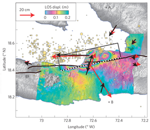
Map of ground deformation associated with the 2010 Haiti earthquake, observed with Japan’s ALOS-1 satellite. One colour cycle represents 20cm of ground displacement. The interpretation of the ground deformation data suggested that a previously unknown fault sub parallel to the Enriquillo–Plantain Garden fault zone (EPGFZ) ruptured.
Image credit: JAXA/METI, E. Calais
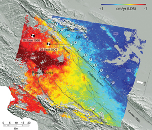
InSAR observations from the ERS and Envisat satellites for strain accumulation along the San Andreas fault in Central California.
Image credit: ESA, M. de Michele
Volcanic Hazards
InSAR can also contribute to volcano monitoring in two ways. An eruption is inevitably preceded by the ascent of magma to shallow levels in the Earth’s crust. When magma accumulates in a reservoir, the ground surface above the reservoir inflates. Satellite-based InSAR can detect this inflation, providing early warning of forthcoming volcanic unrest long before there are any other signs of activity.
An eruption occurs when the reservoir develops enough pressure so that magma forcefully propagates towards the surface. The expansion of the magmatic conduit causes surface deformation in the summit area, which can also be detected by InSAR. Large explosive eruptions are generally preceded by significant lateral summit deformation and/ or by the collapse of a lava dome. Active volcanoes do not generally have ground-based instrumentation in the summit areas, so space-based InSAR can provide unique data for early warning of volcanic activity that cannot be acquired through any other means.
The combination of moderate-spatial resolution background monitoring of all volcanoes in an arc with high-spatial resolution summit monitoring of volcanoes showing high levels of unrest forms a powerful volcano observation system that can track the movement of magma from its arrival under a volcano to its eruption from the summit. This is a process that cannot be observed using sparse ground-based measurement networks.
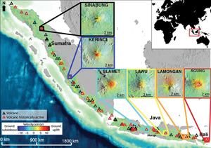
A 2007–2009 ground velocity map of the Indonesian volcanic arc obtained from ALOS-1 InSAR data. The insets show six volcanoes that inflated during the observation period (uplift is shown in red). Sinabung and Kerinci volcanoes in Sumatra and Slamet in Java erupted following inflation.
Image credit:JAXA/METI, E. Chaussard
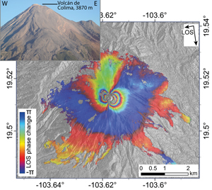
A TerraSAR-X interferogram of the summit of Colima volcano in Mexico that shows up to 6cm of ground displacement prior to an explosion of the lava dome in January 2013.
Image credit: DLR, J. Salzer
EO Assets
CEOS Agencies are operating several SAR satellite systems with different spatial resolutions, repeat frequencies, and wavelengths that can be combined for effective hazard monitoring. Europe’s new Sentinel-1 constellation is set to observe all of the Earth’s landmasses and islands every 6–12 days, ensuring the availability of pre-event imagery for virtually all seismic events. This moderate spatial resolution imagery is complemented by high spatial resolution data from Germany’s TerraSAR-X, Italy’s COSMO- SkyMed, Canada’s Radarsat-2, and Japan’s ALOS-2.
GEO’s GSNL initiative pursues two broadly defined goals, aimed at advancing the scientific understanding of geological hazards and promoting the use of EO for disaster-risk assessment.
The first goal is to improve monitoring by effectively combining the assets of multiple CEOS Agencies. The time- dependent post-seismic deformation following earthquakes is best resolved using multiple SAR satellites. The COSMO- SkyMed constellation of four satellites is invaluable for monitoring volcanic eruptions.
The second goal is the integration of space-based and ground-based observations and to create societal benefit by reducing disaster risk. The initiative is developing an online infrastructure for open access to satellite and ground-based data, facilitating the application of advanced data analysis techniques to different geohazard areas around the world. Each Supersite is led by a scientist affiliated with the local monitoring agency to ensure direct interaction with CEOS.
Geohazard Supersites
‘Permanent Supersites’ are geographical areas in which active geological hazard(s) poses a threat to human population and/or critical facilities, and for which scientific investigations are needed to better understand the geological process narrowing down the uncertainty in hazard and risk assessment.
Event Supersites are sites affected by a major geological event (e.g earthquakes, volcanic unrest or eruption, landslides) for which a scientific forum of experts, endusers and data providers is set up during or in the immediate aftermath of the event.
The current Supersites are given below. They are among the most active tectonic and volcanic areas in the world.
Permanent Supersites: Hawai’i (USA), Iceland, Marmara Sea/North Anatolian Fault Zone (Turkey), Mt. Etna Volcano (Italy), Mt. Vesuvius/Campi Flegrei (Italy), New Zealand, and Cotopaxi and Tungurahua volcanoes (Ecuador).
Recent event Supersites: Sinabung Eruption (Indonesia), Napa Valley Earthquake (USA).
The EC has provided extra funding to advance the Supersites concept in Europe. The European Supersites will not only provide open access to the raw geophysical data streams but also to higher-level data products. This is to facilitate crisis assessment by non-experts.
Two recent geological events illustrate how EO data can beused.
2014 South Napa Earthquake
The magnitude 6.0 earthquake of August 24, 2014 that struck the southern Napa Valley northeast of San Francisco, California demonstrated the role that EO plays in response to earthquakes. This event caused extensive damage in Napa County and adjacent areas. Interferograms from both satellite and airborne systems started to become available just 3 days after the earthquake.
The early interferograms were used immediately by the United States Geological Survey (USGS) National Earthquake Information Center (NEIC) to refine models for the distribution of fault slip during the earthquake. Field teams coordinated by the California Geological Survey and the USGS used the imagery to map small surface ruptures in the field at many locations, including a fault cutting through the runway of the Napa County Airport.
After the earthquake, additional images from many SAR satellites were used to map the continuing fault movements (up to 10cm in the first 2 months after the earthquake) that caused additional damage to roads and other infrastructure. The InSAR imagery will next be used to update fault and seismic hazard maps, which will affect decisions on where and how to rebuild structures.
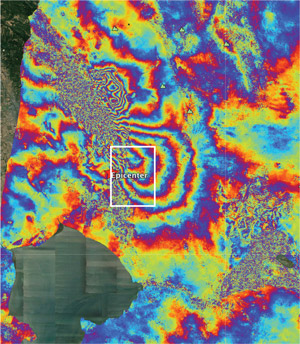
Map of the deformation of the Earth’s surface caused by the 2014 South Napa earthquake, generated from two COSMO- SkyMed images. One colour cycle indicates 2cm of permanent surface movement and the inset map reveals a discontinuity that identifies a fault rupture cutting through the Napa County Airport.
Image credit: ASI, NASA/JPL-Caltech, Università degli studi della Basilicata, ARIA, Google Earth
2014 Eruption in the Bardarbunga Volcanic System
SAR data provided to the Icelandic volcanoes Supersite has been important in the response to the fissure eruption of the Bardarbunga volcanic system in Iceland, partly located under the Vatnajökull ice cap, that began on August 29, 2014. The eruption produced about 1km3 of lava as of November 2014, which makes it the largest lava-producing eruption in Iceland in 230 years. Air traffic remains uninterrupted because only minor amounts of ash have been generated, however volcanic gases (in particular SO2) are causing widespread pollution.
The eruptive activity was preceded by the formation of a 45km-long, 2m-wide magma-filled crack extending from the Bardarbunga caldera to the eruption site. COSMO-SkyMed and TerraSAR-X InSAR images are used together with GPS geodesy data to understand the associated ground and ice deformation. Scientists working on the EC-funded Supersite project provided daily updates on ground deformation to the Icelandic Civil Protection.
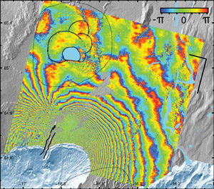
COSMO-SkyMed interferogram of the deformation associated with the dike of the 2014 Bardarbunga eruption in Iceland. One phase cycle corresponds to 1.6cm of ground displacement.
Image credit: ASI, S. Dumont, M. Parks
Proposed Southeast Asia Natural Laboratory for Geohazards
A new Natural Laboratory activity has been proposed for a region including Indonesia and the Philippines, which combine high levels of earthquake and volcanic hazard with high population density. According to a new report by UNISDR, volcanoes in Indonesia and the Philippines account for more than 75% of global volcanic risk. The volcanoes are currently monitored from the ground using seismic and geodetic methods. The establishment of the Natural Laboratory would lead to systematic space-based InSAR monitoring and allow stakeholders to receive state- of-the-art science data products to assist their disaster prevention and emergency response activities.
Case study contributors
Falk Amelung (University of Miami)
Eric J. Fielding (Jet Propulsion Laboratory, California Institute of Technology)
Freysteinn Sigmundsson (University of Iceland)