The International Charter on Space and Major Disasters
Every year, millions of people worldwide are affected by natural disasters. Increased frequency and intensity of events, along with concerns about possible links to climate change, has put disasters high on the list of modern-day challenges.
Recognizing the unique role that the combined satellite assets of many space agencies could play in support of disaster response, ESA and the Centre National d’Etudes Spatiales (CNES) initiated the International Charter on Space and Major Disasters following the UNISPACE III conference in 1999. They were joined by the Canadian Space Agency (CSA) in 2000, and together the three initial members laid down the operational foundations of the Charter. The aim was to coordinate satellite EO to support civil protection agencies in their response to disasters. Today, 15 satellite operators are members of the Charter: CNES (France), CNSA (China), CONAE (Argentina), CSA (Canada), DLR (Germany), ESA (Europe), EUMETSAT (Europe), INPE (Brazil), ISRO (India), JAXA (Japan), KARI (South Korea), NOAA (US), ROSCOSMOS (Russia), USGS (USA), UK Space Agency (UK), and DMCii (UK).
Since its foundation in 2000, the Charter has been activated 420+ times in 110+ countries worldwide.
The Charter in Action
The Charter is focused on the response phase of the DRM cycle and its functions are simple: to task satellites in response to a major disaster and to provide fast access to satellite data to support disaster response. The Charter provides satellite EO- based products as maps to assess the extent of the impact and damages caused by a disaster. the Charter responds to major disasters, addressing a portion of the 200–400 catastrophes that occur annually around the world.
First activated for landslides in Slovenia in November 2000, the Charter has brought space assets into action in well over 110 countries for over 400 natural and technological disasters, including flooding, hurricanes, tsunamis, earthquakes, forest fires, volcanic eruptions, and oil spills. Some notable Charter activations include the 2004 Asian tsunami, the 2008 cyclone Nargis in Myanmar, the January 2010 Haiti earthquake, the Deepwater Horizon oil spill in the Gulf of Mexico the same year, followed by the flooding across North West Pakistan, the 8.9 magnitude earthquake and following tsunami in Japan in March 2011, the 2012 typhoon Bopha in the Philippines, the Typhoon Haiyan that devastated the Philippines in November 2013, and the 2013 flood event in India.
In 2014, the Charter also contributed for the first time to the search for aircraft debris following the disappearance of Malaysia Airlines Flight 370 and provided imagery for the international emergency teams combating the spread of the Ebola virus. In this last case, optical satellite imagery was used to provide geocoded products of urban sprawl and infrastructure and helped support planning of evacuation routes and Ebola recovery hospitals in five African countries (Guinea, Liberia, Sierra Leone, Nigeria, and Senegal).
Charter operators are at readiness 24 hours a day to deal with requests for assistance from civil protection authorities.
Upon receiving a request, they check the identity of the caller and verify that the information needed to respond to the emergency is specified correctly. This information is then passed to an on-call officer who analyses the request and the scope of the disaster with the user to establish how to use the satellites that can provide data to the Charter to their best abilities. The final step is to prepare an acquisition and processing plan using the available space resources. Data acquisition and delivery take place on an emergency basis and a Charter Project Manager qualified in data ordering, handling, and application assists the user throughout the process.
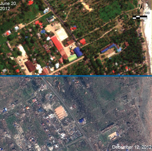
Example of a satellite EO-based product using optical imagery comparing an area before (GeoEye satellite) and after (SPOT satellite) the landfall of Typhoon Bopha in the Philippines in December 2012. It is worth noting the damage to buildings and tree plantations.
Image credit: Manila Observatory
The Charter can rely on both radar and optical satellites operated by its 15 members. Imaging radar has an all- weather capability and is particularly adapted to monitor the impact of flooding and oil spills. Optical satellites are well suited for damage mapping – medium resolution for a snapshot of overall effects, high to very high resolution to depict damage to road networks or even individual buildings – which is particularly important for organizing rescue services after an earthquake or a cyclone. The resulting products comprise maps and geocoded image overlays showing flooded surfaces, linear elements (affected roads, bridges), hot spots, burnt areas, landslide scars, or eruptive edifice, depending on the specific characteristics of each disaster.
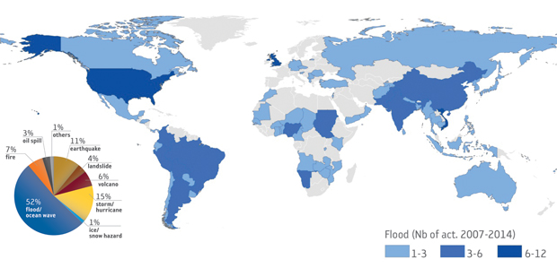
As illustrated below, the Charter is frequently activated for weather-related disasters such as flooding and ocean storms – representing more than 70% of Charter activations – while solid Earth-related hazards (earthquakes, volcanic eruptions) represent 20% of Charter activations.
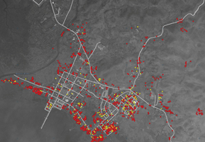
Satellite EO-based product using very high-resolution optical imagery (WorldView satellite) to analyze the damaged structure caused by the Super Typhoon Haiyan in November 2013. In red, the destroyed structures; in yellow, structures that may be damaged. This map was elaborated by UNITAR/UNOSAT, which regularly collaborates with the Charter. The same methodology is also very useful to estimate damage after an earthquake.
Left: Diagram showing disaster types (%) covered by the Charter since its inception in 2000. Over 50% of activations concern flooding. Top: Map illustrating the number of flooding events by country covered by the Charter between 2007 and August 2014 (in total 172 flooding events worldwide).
The Charter User Base
The Charter can be activated by a predefined list of appointed users, known as Authorized Users (AUs). Until now AUs were typically disaster management authorities, from countries of Charter member agencies, able to request Charter support for emergencies in their own country or in a country with which they cooperate for disaster relief. Since its inception, the Charter has demonstrated a strong commitment to expanding its number of users. Initiatives include collaboration with the international humanitarian community via the United Nations Office for Outer Space Affairs (UNOOSA) and the Operational Satellite Applications Programme (UNOSAT) at the United Nations Institute for Training and Research (UNITAR), that are active in many countries and can submit requests to support in-country UN relief agencies, and Sentinel Asia, a regional network for EO-based emergency response in 32 countries. In 2012, Charter members, conscious of the need to improve Charter access globally, adopted the principle of Universal Access: any national disaster management authority is now able to become an AU and submit requests to the Charter for emergency response. Charter procedures must be followed, but the affected country does not have to be a Charter member. Universal Access follows the spirit of Charter members to enhance Charter access; it is also a response to a formal request from the intergovernmental GEO Secretariat in 2007 to make Charter requests available to more users from the 89 GEO member states. The Charter works on a 6-month rotational basis. The Korea Aerospace Research Institute (KARI) has been the Primus Inter Pares since October 2014 and, as such, is the current formal interlocutor of user organisations in the Universal Access process.
Universal Access benefits national disaster management authorities previously unable to make direct requests to the Charter during emergency situations, further strengthening theCharter’s contribution to disaster management worldwide. Perhaps more critically, the Universal Access principle opens the door to a global network of Charter users and value-adding specialists that will develop a capacity to effectively use satellite EO during disasters. This capacity can contribute to limiting the impact of disasters when they occur. The Charter is working with UN bodies, Sentinel Asia, and GEO to improve awareness about satellite mapping at national, regional, and international levels and to promote the Universal Access initiative.
In 2013, Geoscience Australia was granted the right to act as the AU for Australia on behalf of Emergency Management Australia (EMA). In November 2013, they activated the Charter for wildfires in New South Wales.
As a first-time user of the Charter under the new Universal Access arrangements, Geoscience Australia accessed several sources of satellite imagery and provided derived information to Australian emergency managers.
" The data provided broad-scale coverage of the fires that was useful for overall situational awareness and damage analysis. The assistance we received was very much appreciated. ”
– End user: EMA and the Rural Fire Service of New South Wales
Concerning operations, the dialogue with the user during a Charter activation is important, allowing a good understanding of the Charter-provided EO products by the user and adapting (if necessary) satellite acquisitions to the needs of the unfolding emergency. The Charter gathers feedback from users after each activation in order to assess the utility of the service and to identify areas for improvement of performance. So far, feedback from national users is showing a strong interest in the contribution that the Charter can make by providing rapid, objective, and free information to monitor an emergency and its impact.
" Data Access through the Charter was very valuable for map production in this crisis situation. ”
– End user: Federal Office of Civil Protection and Disaster Assistance (BBK) / GMLZ (German AU).
FLOOD IN GERMANY | 2013
Beyond the fundamental subject of triggering the system, the way the Charter service is provided and exploited generally requires collaboration, and local organizations can play a key role because they are close to the theatre of operations. Once an activation is requested, the Charter designates a Project Manager – not necessarily from a country of a Charter member – who plans for the appropriate EO acquisitions and manages their dissemination and exploitation. This aspect is also under investigation for the many countries not yet closely linked to the Charter.
“ The value-added products provided very useful information of the flood water extent in Far Eastern Russia. The products were helpful for the purposes of disaster monitoring, destruction assessment, and relief operations. ”
– End user: EMERCOM (Russian AU)
FLOOD IN RUSSIA | 2013
The Charter is a striking example of what space agencies working together can achieve. However, perhaps more importantly, the Charter has awakened the international community of practitioners of DRM and end users to the opportunities satellite EO offers, not only for disaster response, but more generally in support of the full cycle of disaster management. In that context, many of the same agencies that spearheaded the development of the Charter are working together through CEOS to demonstrate how satellite EO can be applied to risk reduction. The CEOS Working Group on Disasters has initiated pilot projects on floods, seismic hazards, and volcanoes, and is working on strategies with the international recovery community to create a Recovery Observatory. These activities primarily focus on other phases of risk management than the emergency response phase and in particular on risk assessment with the aim to better understand hazards using satellite-based observations. As far as the immediate response phase is concerned, by raising the profile of satellite EO, the Charter has greatly increased the user community’s interest in satellite EO-based solutions. the Charter will continue to offer operational response services and has served a compelling role as a precursor to operational full-cycle support of satellite EO to the disaster risk management community.
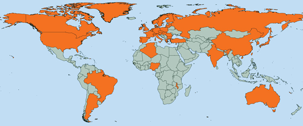
Map showing countries with direct access to the Charter in September 2014 (orange). Universal Access allows national users from new countries to directly submit activation requests to the Charter.
Case study contributors
Philippe Bally, Maurice Borgeaud (ESA)
Monique Viel (Argans Ltd c/ESA)
Andrew Eddy (Athena Global c/ESA)
Hyo-Suk Lim, Ing. Hyun-Ok Kim (KARI)
Jens Danzeglocke (Deutsches Zentrum für Luft- und Raumfahrt e.V.)