Use of Satellites for Flood Disasters in Southern Africa
Alongside research partners, CEOS is implementing disaster modelling and monitoring capabilities and working more closely with end users in order to build and sustain capacity for optimal flood and water management using satellite imagery. The end users include national, regional, and international agencies responsible for preparedness, disaster management, water resources management and flood/ drought prediction and assessment. These projects are contributing to risk reduction in Southern Africa from disaster events in terms of people’s lives and livelihoods, as well as reducing the cost for assessments and recovery. Improvements are being made around individual decision making and directly related to the introduction of satellite-based products and services, especially in the area of flooding. Advancements are also being made by local, national, regional, and international agencies in generating their own products and validating the satellite data using crowd-sourcing techniques and open source tools.
The experiences of the Italian authorities demonstrates the importance of organisation, cooperation between stakeholders, and the integration of satellite data with models, informed by interaction with regional and local authorities, to produce accurate and timely flood map products in support of disaster preparedness and response.
Namibia
In Southern Africa the Namibian Department of Water Affairs and Forestry and the National Water Resources Authorities are using satellite-derived products and services to warn the public of impending floods; monitor algal blooms in reservoirs; and track flood, drought, and health- related events as they unfold at the national level. The Regional Centre for Mapping of Resources for Development (RCMRD) provides disaster risk management support on a regional basis to their constituent countries using the same remote-sensing capabilities.
These flood and drought monitoring and modelling capabilities have been used by the Namibian government since 2008, when the worst flooding in two decades occurred in the northern part of the country. At that time, the affected population chose to not take action ahead of the flood because no serious flooding had occurred for a long time and flood forecasts from satellite remote sensing were not widely available. People within the areas of concern did not heed warnings by national agencies and this resulted in approximately 250,000 people directly affected, as well as significant property damage. A state of emergency was declared and many people were rescued from rooftops using boats and helicopters. During the following year, extensive use of satellite data allowed national agencies to improve their analyses and share them with news outlets. The satellite imagery analysis showed not only where to expect flooding, but also indicated potential severity, so that people within the risk areas could gauge the level of danger. This enabled effective, informed, pre-emptive action during the flood season.
In the following years, CEOS Agencies and their partners in academia and at research institutions joined forces to develop a pilot program aimed at improving these modelling and monitoring services by incorporating new satellite assets for higher spatial, spectral, and temporal resolution. These programs also include advanced capabilities for crowd-sourcing to improve validation. These advancements make use of the Internet and are based on open source tools and services that are freely available to the public.
The tools and services are platform-independent and are in widespread use via personal computers and smartphones. Processing services and predictive models that were unavailable in the region 5 years ago have been converted to open-source code that is now freely available. Training on installation and operation of these open-source services have been conducted in-country on numerous occasions and those training courses are available as webinars, videos, and presentations that are all posted on the Internet for public access. In April 2014, CEOS Agencies kicked off a 3-year pilot to extend this approach to Southern Africa and establish a vision for sustainable satellite-based flood services in the region.
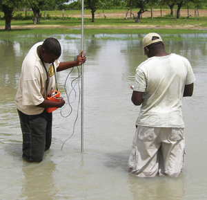
Namibian hydrologists manually measure flood water depth for map validation.
Mozambique
The Zambezi River is the fourth largest river in Africa, sustaining biodiversity and agriculture and generating hydroelectric power. However, nearly every year, moderate- to high-magnitude floods place hundreds of thousands of people and their livelihoods at risk. The countries in the Zambezi basin, in particular the downstream country of Mozambique with its vast delta area, have limited infrastructure and resources and thus lack the capacity to establish effective flood management, mitigation, and relief services plans or a flood forecasting system. Although some local flood forecasting efforts in the Zambezi basin exist, there is currently no integrated flood warning system, primarily due to poor communication facilities and limited exchange of information and data in real-time. Furthermore, flow and water-level measurement stations are sparse in most countries in the region.
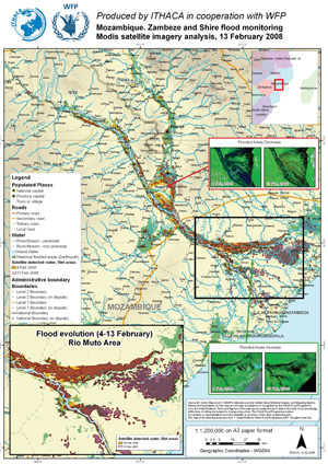
The lack of information makes emergency response such as food aid distributions by the United Nations World Food Programme (UN WFP) very challenging. Reliable maps showing infrastructure and the current state of rivers and floodplain inundation (as illustrated in Figure 1) need to be delivered in near-real time to UN WFP field officers at ground level. With composite images and flood products from the array of satellites and services outlined below, there is a dramatic increase in mapping accuracy, as well as detailed information on the rise or fall of floods on a regular basis during the emergency response. Observations of floodplain inundation over time allow disaster relief agencies like the UN WFP to identify the most significant flood events and allocate resources and direct operations accordingly.
The UN WFP is also involved in investigating the operational value of a flood forecasting model that derives a simple flood index to be used with regional rainfall predictions and observed antecedent and near real-time soil moisture fields as observed by NASA’s upcoming Soil Moisture Active Passive (SMAP) mission. This investigation is taking place under NASA’s SMAP Early Adopter program with lead investigators from the UN WFP.
Tools and Services
Flood information on both the global scale and at the local level is utilized in national and regional settings by practitioners in those areas through an integrated set of product publishers and consumer clients.
Flood maps are made freely available in near-real time every day by a unique global flood monitoring system funded by NASA and operating at both the Goddard Space Flight Center (http://oas.gsfc.nasa.gov/floodmap) and at the Dartmouth Flood Observatory hosted by the University of Colorado (http://floodobservatory.colorado.edu) using daily images from low- and moderate-resolution instruments. With composite images, NASA produces cloud-free maps showing the locations of flooded areas along rivers, where hundreds of thousands of people may be affected.
The Continuous Routing of Excess Storage (CREST) model developed by the University of Oklahoma was implemented in Namibia, at the RCMRD, and at the South African National Space Agency during early 2014 and is currently operating daily to forecast floods on a local basis in the region. CREST is supported with on-site training by NASA’s SERVIR program and on-going support is being provided by the University of Oklahoma.
The University of Maryland Global Flood Monitoring System provides flood monitoring and forecasts every 3 hours at both 12-km and 1-km resolutions. The system uses satellite-based rainfall information from the Multi- satellite Precipitation Analysis system using tropical rainfall measuring mission (TRMM) and global precipitation measurement (GPM) plus conventional information and a hydrological and routing combination model (the Dominant river Routing Integrated with VIC Environment or DRIVE system). The system provides global flood detection, stream-flow estimates, and inundation-mapping images and output data at resolution as fine as 1-km and rainfall forecasts using the NASA GEOS-5 model.
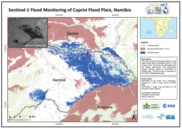
The Water Observation and Information System is an open-source tool that enables African water authorities to produce and apply a range of satellite EO products needed for Integrated Water Resource Management in Africa. The system has been developed in close collaboration with eight trans-boundary and national water authorities in Southeast Africa. Each water authority has been trained in the use of the system in order to develop a local capacity for monitoring, assessing, and inventorying water resources using satellite data. In the case of Namibia specifically, the capabilities for hydrological modelling, flood forecasting, and mapping have been demonstrated (see Figure 3). The full software package (TIGER) has been publically released.
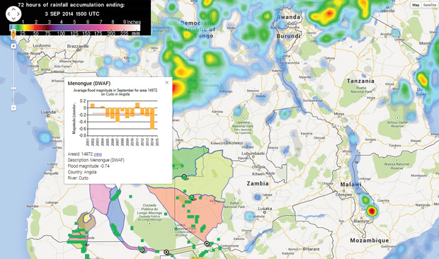
The Open GeoSocial Application Programming Interface (API) provides high resolution optical and radar imagery and turns them into flood maps on an expedited basis to supplement the products from the daily modelling and monitoring systems. RCMRD was the first to implement the API, and the second site targeted for installation is Namibia. The “Dashboard” node of the API is being used by the Namibia Department of Water Affairs and Forestry to post their daily flood bulletins, river gauge readouts, and emergency station (e.g., schools) status, in addition to housing the monitoring and modelling flood maps.
The approaches outlined above are being extended to two other CEOS regional pilots – South East Asia, and Caribbean/Central America – mirroring the approach taken in Southern Africa. All three regional pilots are being integrated with a global component for synchronization of records and results.
Conclusion
The CEOS regional Flood Pilots offer a unique vehicle to federate a myriad of initiatives that independently offered increased capacity, but collectively begin to offer the perspective of a sustainable approach to flood management on a region-by-region basis. Combined with the global efforts put forward by the CEOS Flood Pilot, CEOS and its local, national, and regional end users are leading the way toward the definition of a global system for high-resolution flood and water management.
Map showing inundation extent in combination with infrastructure and other annotations.
As one of its first images, the Sentinel-1a mission covered the flood extent in the Caprivi plain on April 13, 2014. The Sentinel-1a Interferometric Wide Swath mode allows flood maps in high resolution of 20m.
Namibia Flood Dashboard integrates satellite- and ground-data products for user analysis.
Case study contributors
Pauline Mufeti, Victoria Shafidi (Namibian Department of Water Affairs and Forestry)
Denis Macharia, Eric Kabuchanga, Faith Mitheu (RCMRD/ Nairobi)
Kashif Rashid, Emily Niebuhr (UN WFP)
Stuart Frye (SGT)
Pat Cappelaere (Vightel)
Dan Mandl, Matt Handy, Fritz Policelli, John Bolten (NASA, Goddard Space Flight Center)
Robert J. Kuligowski (National Oceanic and Atmospheric Administration)
G. Robert Brakenridge (University of Colorado)
Bob Adler, Huan Wu (University of Maryland)
Guy Schumann (University of California, Los Angeles)
Benjamin Koetz (ESA/TIGER Initiative)
Patrick Matgen (Lippmann Institute/HASARD Project)
Andrew Eddy (Athena Global)