Over the past two decades, the annual economic losses resulting from disasters worldwide have increased from $US50 billion to US$200 billion. Increasing emphasis is being placed on understanding and managing risk in the key financial organizations that deal with natural disasters, i.e., the re/insurance industry, and the international development banks.
EO satellites provide a wide range of valuable environmental information that is very pertinent to disaster-risk assessment and reduction. This case study explores recent assessments of the utility of EO information already carried out in close collaboration with end-users within the context of their operational activities. These end-user organisations include SwissRe, Willis, Guy Carpenter, Allianz, and PERILS from the re/ insurance sector, and World Bank country operations teams from the international development sector.
Risk Assessment in the Re/Insurance Sector
The uptake of EO-based services is currently rather limited within the insurance sector. A recent survey by the European Association of Remote Sensing Companies (EARSC) shows that less than 1% of total revenues generated by EARSC members are from clients within the insurance and financial areas.
A few years ago, ESA began investigating the potential to expand the use and uptake of EO-based information in cooperation with major industry players through an informal working group. In addition to the technical discussions of what EO could deliver, innovative new business models were considered for delivery of information into the industry. The idea was to use an existing information platform developed and co-financed by the industry itself, through PERILS, an independent, Zurich-based company that provides industry-wide catastrophe data for the insurance sector, intermediaries, and other service-providing organisations.
The initial focus was on floods, as these represent a major source of disaster-related events, with approximately half of all of the activations of the International Charter on Space and Major Disasters being associated with floods. The first step was to define the industry requirements for flood information products and test the feasibility of using EO to meet these requirements through near real-time coverage of a major European flood event, supplying the insurance industry with critical information to rapidly assess exposure and potential losses, and allowing improved risk modelling.
The Insurance working group triggered the trial on Monday June 3, 2013 following the development of a major flood event in Germany, the Czech Republic, and Hungary. During the event, flood-mapping products were produced on an almost daily basis for 10 days and made available to more than 400 individuals from more than 150 organisations of the insurance sector via the PERILS web portal.
A wide range of satellite sensors was utilized for the trial, both radar (COSMO-SkyMed, TerraSAR-X, RADARSAT-2) and optical (SPOT-5/6, Pleiades, MODIS), and Landsat as historic reference data. The daily products provided a combination of low-resolution (50–100m) wide-area coverage for mapping of regions and high-resolution (0.5m) products for cities. Four weeks after the end of the flood event, a maximum flood-extent product was produced and delivered via the PERILS web portal. This product is derived from satellite observations, in-situ observations, and modeling, and delineates the maximum boundaries of the flood event.
The near real-time flood maps were used within the insurance industry mainly to continuously assess their potential losses. The maximum flood extent is used for claims management and to validate and improve existing flood models within the industry.
The general consensus was that the trial had been very useful as a hands-on demonstration of the benefits of EO for a major flood, but that the time interval from the occurrence of the event to the provision of the first flood maps has to be shortened (to within 48 hours maximum) to be fully used in loss estimation. In this flood event, such delays were encountered because, in addition to this trial, the Copernicus/GMES Emergency Service and the Charter were also activated (for Government users) with sometimes conflicting and higher-priority access to the required satellite data.
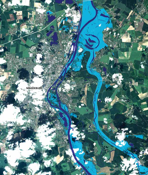
Rapid Flood Extent over the city of Magdeburg, Germany, derived from a Pléiades-HR data (70cm) acquired the 10th of June 2013 during the Elbe River flood event.
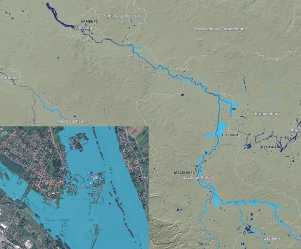
June 2013 Maximum Flood Extent over more than 400km of Elbe River in Germany based on Rapid Flood Snapshots. (Background: SRTM DEM) Image credit: VISTA, SERTIT, USGS.
Inset: Rapid Flood Extent over the area of Zschieren in Dresden, Germany, derived from a Pléiades-HR data (70cm) acquired the 5th of June 2013 during the Elbe River flood event.
Risk Assessment in the International Development Sector
Multilateral Development Banks (MDBs) provide support to developing countries to reduce poverty and stimulate economic growth. This involves dealing with the complex challenges of climate change, rapid urbanisation, threats to food security, natural resource depletion, and the risk of natural disasters. The provision of accurate and consistent geospatial information is a key component of their activities and the world expects MDBs to use the best available datasets to support strategic planning and to ensure that economic growth is achieved in an environmentally sustainable manner.
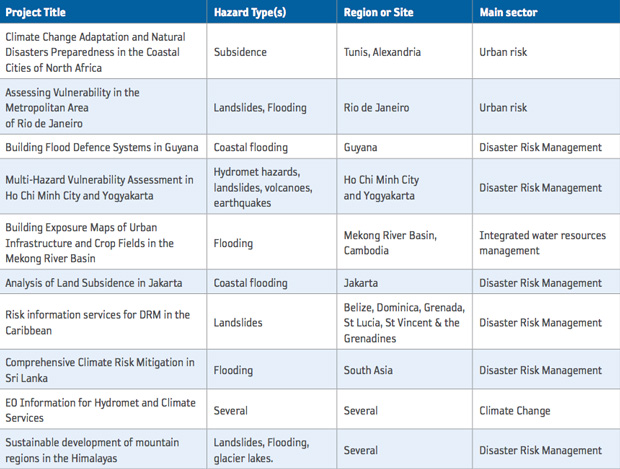
Since 2008, ESA has been collaborating with the main MDBs (World Bank, European Investment Bank, International Fund for Agricultural Development, and more recently the Asian Development Bank) to investigate the use of EO information for the planning, implementation, monitoring, and assessment of international development projects and programmes. ESA and the World Bank have jointly implemented 33 specific technical assistance activities delivering EO-based products and services to World Bank project teams and/or to local stakeholders in the countries where the projects are being implemented. The overall portfolio of projects spans all regions of World Bank operations (i.e. East Asia Pacific, Africa, Latin America & Caribbean, South Asia, and Europe & Central Asia) and a wide range of sectors such as Forestry & Agriculture, Urban Development, Water Resources Management, Marine Resources, Coastal Zone Management and Disaster Risk Management. Ten of these 33 activities concern DRR, as described in the following table.
The rising economic impacts of disasters across the globe are attributed to the growing concentration of assets and population in areas at high risk of natural hazards. Cities of the developing world accommodate more than 50% of the global population and hundreds of billions of dollars worth of assets. The projects focused on demonstrating how EO data and information can support urban risk assessment to support the formulation of better disaster-resilience strategies.
Although there are a number of highly specialized EO products and services addressing the challenges of DRM that are currently being assessed for operational use by World Bank teams, a specific example is given in further detail in the following section.
" This pilot shows that satellite-derived flood information has the potential to satisfy a long-standing industry need for quick and detailed flood information during and after large events. ”
– Eduard Held, Head of Products at PERILS
ESA and World Bank technical assistance activities related to DRR.
Subsidence Risk in Jakarta
Jakarta is highly vulnerable to the impacts of natural disasters. The greatest risk facing the city, one that imposes very high human and economic loss, is flooding. Particularly in the north of the city, the local neighborhoods are extremely vulnerable to damages from seawater intrusion and coastal inundation. This is largely because the flood risk is aggravated by rapid land subsidence. The evidence shows that if sustained at the current rate, subsidence will result in coastal defences sinking to 4–5m below sea level by 2025, resulting in some industrial/residential areas and ports being completely submerged in the coming decades.
Land subsidence in Jakarta is largely caused by uncontrolled ground water extraction – withdrawal of underground water through deep wells to compensate for the lack of access to piped water. It is estimated that 20% of such wells are over 100m deep and often cause aquifers to collapse. Other contributing factors include heavy constructions exacerbated by fast-paced urban development, as well as the natural consolidation of soil and tectonics.
To help address the situation, the World Bank is currently implementing a flood mitigation project in collaboration with Jakarta’s local municipal government (DKI) and the Indonesian Ministry of Public Works. This includes revitalization of Jakarta’s drainage canals and flood retention ponds, establishment of a Flood Management Information System, and increasing the capacity of the existing hydraulic networks. Collection of detailed geospatial information concerning land subsidence patterns greatly contributed to this process.
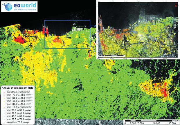
With an archive of imagery with good spatial and temporal coverage spanning the past two decades, EO data yielded land motion information at an unprecedented level of detail and accuracy. As illustrated in Figure 1, two parallel InSAR studies from two different satellites were conducted using:
– Very High Resolution (VHR) COSMO-SkyMed radar data gathered from October 2010 to April 2011, which yielded very high spatial and temporal density of measurements in the specific constructed areas. VHR radar imagery from ASI’s COSMO-SkyMed satellites provides a very dense network of terrain motion measurements over a relatively limited time period;
– High Resolution (HR) ALOS archive data from January 2007 to the end of February 2011, which provided information concerning terrain motion of higher amplitude over the 4-year period. Because of the systematic data collection over strategic areas, L-band radar imagery from JAXA’s ALOS mission can provide measurements over a long time span.
Satellite EO offered a unique insight into past trends as well as state-of-the-art tools for monitoring present and future terrain deformations. The EO results revealed that the sub-districts of Penjaringan, Cengkareng, the South Center of Jakarta, and the suburban district of Cikarang are affected by strong subsidence rates. In the Jakarta Bay (District of Penjaringan), where a system of sea walls, water draining channels, canals, and water reservoirs protecting the land from sea flooding are located, the maximal detected subsidence rate is more than −15cm/ year, resulting in a deformation of more than −60cm over the period of 4 years.
" Previous information on subsidence was largely based on terrestrial sample point monitoring, and did not offer anywhere near the resolution, quality or timeliness possibilities offered by this analysis. This study provided much more recent, comprehensive, and encompassing information at higher resolution than previously available. It was suitable for use both to update previously available data on Jakarta’s subsidence and particularly as a means to achieve a higher sense of urgency when communicating the issue to Jakarta decision makers and stakeholders.
The Government is implementing a World Bank-supported flood mitigation project targeted at restoring existing flood channels. The information on subsidence at a local level provides knowledge to enable a better idea of infrastructure reconfiguration needs going forward in the long-term flood mitigation efforts in Jakarta. The high-resolution analysis provides a more compelling justification for projects and greater impact in project discussions and dialogue with the authorities and stakeholders. The timeliness and relatively quick analysis provides the possibility to shorten the project preparation timeframe. "
– Fook Chuan Eng, Senior Water and Sanitation Specialist, World Bank Jakarta Country Office
The benefits of the mapping products go beyond improvements in resolution and detail in comparison to alternative techniques. In fact, the use of EO was extremely useful in framing a World Bank dialogue with the local government to convey the importance of prevention actions. The occurrence of severe subsidence was relatively well known to the public in the past but it was largely unaddressed as a risk factor despite alarming figures. Institutional fragmentation as well as the absence of effective mechanisms for metropolitan coordination hindered the local government’s ability to act on the policy and technical level. The unique insight offered by satellite EO gave the opportunity to raise the profile of the land subsidence problem and bring it back to light from an entirely new perspective.
Conclusions
It is evident that satellite EO-derived products and services have significant potential to provide key (sometimes unique) information to support risk assessment and the formulation of better disaster resilience strategies for risk reduction.
Over the next few years, the entry into operations of the European EO programme Copernicus, headed by the EC in partnership with the ESA co-funding entity for the Sentinels programme, will see EO data delivered operationally from European and National missions on a previously unprecedented geographic scale, frequency, and quality.
The opportunity therefore presents itself to continue working with key stakeholders in the field of DRM to establish the use of satellite EO-derived information as ‘best-practice’, on a fully sustainable basis.
Top right: land deformation map over Jakarta at the scale 1:30,000 derived from the analysis of 12 COSMO-SkyMed data products acquired from October 2010 to April 2011.
Background: Land deformation map over Jakarta at the scale 1:50,000 derived from the analysis of ALOS data acquired from January 2007 to February 2011. Some sectors of Jakarta Bay show an accumulated subsidence of more than 60mm.
Image credit: Altamira Information; COSMO-SkyMed data distributed by e-Geos.
Case study contributors
Stephen Coulson, Ola Grabak, Philippe Bally (ESA)
Eduard Held (PERILS)