Sentinel Asia – Space-Based Disaster Management Support
The Sentinel Asia initiative is a voluntary, grass-roots and best-effort-based collaboration between regional space agencies and DRM agencies for humanitarian purposes. Sentinel Asia applies remote sensing and Web-GIS (Geographic Information System) technologies to DRM in the Asia-Pacific region and aims to:
– Promote the use of space technology for DRM;
– Build partnerships between DRM and space agencies in the Asia-Pacific region;
– Promote utilization of data products by end users;
– Improve public awareness and knowledge transfer through capacity building activities;
– Provide a platform to perform these activities.
Emergency Observation Activities
When a major disaster occurs in the Asia-Pacific region, the Sentinel Asia team triggers emergency observations from a number of EO satellites, based on specific observation requests of the Joint Project Team (JPT) and Asian Disaster Reduction Center (ADRC) members.
The ADRC was established in Kobe, Hyogo prefecture in 1998 to enhance the disaster resilience of its member countries, to build safe communities, and to create a society where sustainable development is possible. The Center works to build disaster-resilient communities and to establish networks among countries through many programs including personnel exchanges.
The following subsections are examples of events that triggered a Sentinel Asia response and detail the corresponding actions.
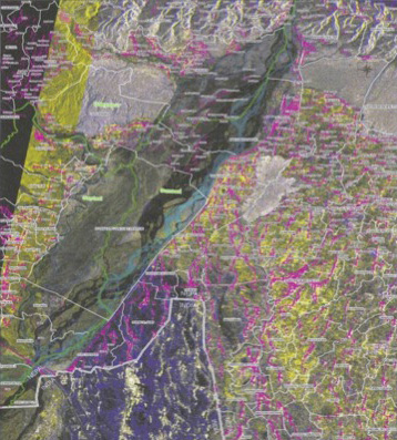
Large-Scale Flood, Nepal, August 2008
A large-scale flood occurred after a dyke burst in Sunsari district in southeastern Nepal on August 18, 2008. JAXA made an emergency observation using the Advanced Land Observing Satellite (ALOS) on August 22 and 24 (see Figure 2 (b)), following a Sentinel Asia-mediated request from the Nepalese International Centre for Integrated Mountain Development (ICIMOD) Survey Department and the Department of Water Induced Disaster Prevention.
JAXA-generated products indicating the inundation area were provided immediately to the Nepalese government. By overlaying these data with census information on population and houses, it was possible to create a map of the affected area (Figure 3) as well as data on the amount of damage, the potential number of victims, and the number of houses affected. This information was used to rescue victims, create a recovery plan, and to manage relief payments.
Long-Term Deluge, Thailand, October 2010
Long-term deluges tend to occur once every 50 years in the central and northeastern parts of Thailand; the last such event occurred in October 2010. In response to a Sentinel Asia request from the Geo-Informatics and Space Technology Development Agency of Thailand (GISTDA), JAXA made emergency observations with ALOS on October 21, 2010 and provided the data to GISTDA using the Wideband InterNetworking Engineering Test and Demonstration Satellite (WINDS).
GISTDA generated inundation maps using the ALOS imagery and reported to the Cabinet Office every day.
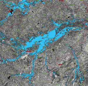
By overlaying house distribution information on a PALSAR-derived inundation map (Figure 4), the number of affected houses was counted and reported. The Thai government decided to compensate households whose homes had been directly affected and used these data to inform its relief payments.
Map of the damaged area overlaid with census data.
Image credit: Survey Department of Nepal, JAXA
Flood inundation map generated using ALOS/PALSAR imagery. Blue shows the inundation area extracted from satellite imagery analysis.
Image credit: GISTDA
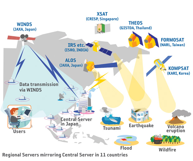
Conceptual illustration of emergency observation and data transmission via WINDS communications.
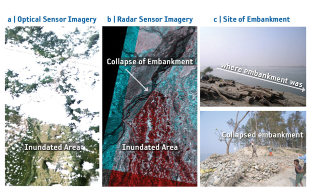
Flood in Nepal caused by the collapse of an embankment in August 2008. (a) Image from AVNIR-2 (optical sensor). (b) Image from PALSAR (radar sensor) aboard ALOS. Inundated area is shown in red. (c) Photo taken in December 2008 showing the area of collapsed bank (approximately 2–3km in length).
Great East Japan Earthquake, March 2011
A magnitude 9.0 earthquake, the strongest ever recorded in Japan and the fourth largest on world record since 1900, occurred in the Pacific Ocean near the Tohoku region at 14:46 JST on March 11, 2011. The earthquake and subsequent tsunami caused massive destruction along the Tohoku-Kanto Pacific coast of Japan.
JAXA immediately planned emergency observations using ALOS and simultaneously asked Sentinel Asia and the Charter (on behalf of the Cabinet Office) to carry out emergency observations. As a result, ALOS and other international satellites provided more than 6,000 satellite images for assessment after the earthquake. These images were processed and analyzed to facilitate their use by disaster management organizations and were provided to ten ministries, agencies, organizations, and municipalities, including the Cabinet Secretariat and the Cabinet Office for disaster management. The images helped to determine the extent of the damage over wide-ranging areas that could not be viewed from the ground or by aircraft and to plan disaster countermeasures.
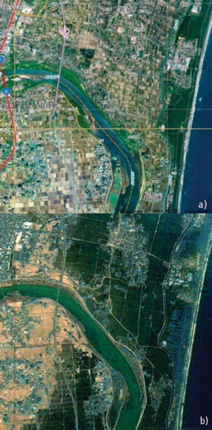
Satellite images of Natori: a) pre-earthquake observation by ALOS; b) March 14, 2011 by THEOS.
Image credit: JAXA, GISTDA
Improving the Connection to End Users and Becoming a Community-Operated System
Sentinel Asia Success Story (SASS) is an activity aimed at increasing:
1. Regional cooperation to promote utilization of Sentinel Asia by end users;
2. Local awareness and knowledge transfer through capacity building;
3. Human resources and human network development.
The following are examples of SASS activities.
Sentinel Asia Success Story in the Philippines
JAXA has been implementing SASS in the Philippines since 2009. ALOS pan-sharpened imagery and a Digital Surface Model (DSM) are used to map hazards related to lahars near Mt. Mayon, floods in Iloilo city, and landslides in Antique province. These products were created by the Philippine Institute of Volcanology and Seismology (PHIVOLCS), the Philippine Atmospheric, Geophysical and Astronomical Services Administration (PAGASA), and the Mines and Geoscience Bureau (MGB), respectively. This first phase of mapping occurred from the beginning of 2009 to March 2010. In the second phase, beginning in April 2010, Global Satellite Mapping of Precipitation (GSMaP) data have been used to produce landslide warnings in Albay; interferometry has likewise been used to monitor land subsidence in the Manila area and earthquake/volcanic eruptions at Mt. Mayon, Mt. Taal, and the Valley Fault.
Volcanic activity was recorded at Mt. Mayon in Luzon from December 14, 2009 and lava was confirmed to be flowing from the crater on December 20. About 47,000 people living near the volcano evacuated after warnings were issued by the Provincial government. JAXA made emergency observations with ALOS on December 25, 2009 at the request of PHIVOLCS through Sentinel Asia. PHIVOLCS created a lava deposit map of the eruption, which was used to inform decision makers at the National Disaster Coordinating Council (NDCC). Lava flow and lahar hazard maps were prepared beforehand using ALOS DSM in a cooperative effort between JAXA and PHIVOLCS, and these were supplemented by updated lava deposit data collected during the eruption.
GLOF Early Warning in Bhutan
The ADRC implemented the Glacial Lake Outburst Flood (GLOF) early warning system in Bhutan from 2009 to 2012, based on community cooperation in the Mo River basin with assistance from the Ministry of Home and Cultural Affairs, Bhutan. In this system, villagers living in an upstream, safe area are connected to the river-level gauging system and when they are alerted by the alarm they warn residents in downstream, hazardous areas.
After creating a map with elevation data for the upstream area of the Mo River and a hazard map using ALOS imagery based on past flood records in Punakha, community-based river-level gauges were installed for the GLOF early warning system. In addition, disaster education and training was carried out at the community level with local residents.
The Future of Sentinel Asia
Sentinel Asia’s target is to provide up-to-date disaster information to end users and to help them better utilize it. JAXA has started an activity called “Mini-project” in collaboration with the Asian Institute of Technology (AIT) from 2013. This activity aims to:
1. Organize groups, including end users themselves, to make high-quality value-added data products for end users;
2. Improve pre-disaster preparedness by sharing existing hazard and risk maps, as well as ground GIS and other data, among group members and make new maps using Open Street Map;
3. Perform post-disaster evaluations.
In 2013, mini-projects were conducted in Sri Lanka, the Philippines, Bangladesh, and Myanmar. In 2014, mini- projects have been conducted in Indonesia and Vietnam. This activity will be expanded to other countries in the near future. A good human network is the foundation of the projects.