The Italian system of Civil Protection has engaged a number of national agencies, in particular the Italian Space Agency (ASI), in a variety of disaster response activities. This includes cross-agency collaboration on flood-extent mapping.
The experiences of the Italian authorities demonstrates the importance of organisation, cooperation between stakeholders, and the integration of satellite data with models, informed by interaction with regional and local authorities, to produce accurate and timely flood map products in support of disaster preparedness and response.
The Italian Framework
The Italian national territory is exposed to a broad range of natural hazards, including floods, which cause fatalities and significant economic damage every year. The vulnerability of the population and built environment is often high and in some cases has been exacerbated by human activities. The National Civil Protection Service operates the Department of Civil Protection (DPC), which has activities covering prevention, forecast and assessment, early warning and alerting, and emergency response and recovery from emergency.
To address its mandate, the Civil Protection Service has organized a comprehensive system that includes a great number of both local and centralised resources. In particular, for hydrogeological risk, a national alert system is run by the DPC and regional authorities built around a network of Functional Centres (CF). One CF covering the national level is located at the DPC and one CF is located in each region.
This national alert system provides services in two phases – forecast of expected flooding and then monitoring and observations of current weather and flooding conditions.
The activities of DPC are daily supported by research efforts through a network of national Competence Centres (CC), focused on the integration of technological and scientific advancements into the emergency response and management cycle. In this framework, the products based on the integration of traditional and innovative EO and ground-based (non-EO) data and technologies foster the ability of Civil Protection Authorities in flood risk management activities.
The ASI has been designated as the CC for EO within the national Civil Protection system. ASI’s role is to support the DPC by developing applications based on EO data, coordinating with other space agencies, and transferring scientific and technical know-how to national authorities. In 2009 following the requirements of the DPC, ASI funded nine technological pilot projects focused on specific hazards such as floods, volcanoes, seismic risk, landslides, fires, oil spills, and air quality. These projects were strongly user driven, and have produced tools, procedures, and applications now operational and used for emergency management.
During an incident, emergency flood monitoring using EO is activated by DPC or at the request of a regional authorised user. The International Centre on Environmental Monitoring (CIMA) Research Foundation is the CC and value adder for hydrogeological risk management and ASI acts as its data provider during flood emergencies. The DPC, ASI, and CIMA work in cooperation as program managers, along with end users at the regional CFs.
Satellite capabilities include the COSMO-SkyMed (CSK) constellation, which plays an important role at a national scale, carrying out monitoring related to rapid mapping, damage estimation, and recovery. The constellation has many desirable characteristics for disaster risk management and response, including high spatial resolution, high revisit time, and day/night all-weather capability. ASI has also signed an agreement with ESA to develop the Italian ground segment for Sentinel data access and exploitation.
Two examples of these capabilities follow – the first is related to the benefits of collaboration between decision makers, end users, and hydrometeorologists and the second shows the benefits of synergy between Sentinel-1 and CSK for monitoring disasters at a national scale. The two examples refer to flood monitoring but the conclusions extend to other hazards.
Liguria Floods, November 2014
The use of satellite EO data in the mapping of flash flooding in small Mediterranean drainage basins like those in Albenga and the surrounding municipalities presents significant challenges for image acquisition planning. Water remains in these small basins for only a few hours, and with satellite imaging opportunities arising on the order of days, the acquisitions need to be planned based on weather and flood forecasts.
Flash flood mapping represents one of the biggest challenges to the limits of usability of satellites for flood monitoring. Acquisitions cannot be scheduled following a flood occurrence, as they would take place over 24 hours after the event, by which time the visible traces of water will no longer be present. Even acquisitions based on weather and flood forecasts are susceptible to failure, due to uncertainty on the location of the flash floods both in space and time.
The Liguria floods of November 2014 were used to test the potential of monitoring a flash flood using weather forecasts to pre-emptively plan acquisitions. Three factors were key to the success of this activity: extensive knowledge of the area by CIMA researchers; close collaboration with forecasters of the regional CF; and close cooperation between CIMA, CF, DPC, and ASI to minimise acquisition planning time.
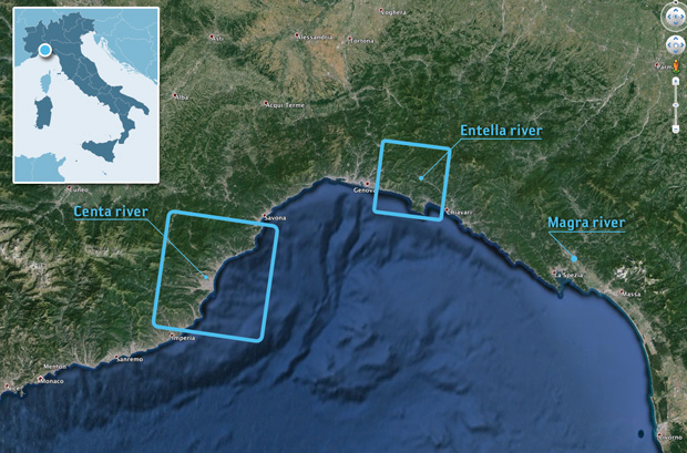
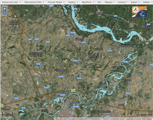
Attention was focused on three flat, sparsely populated areas that are suitable for observation using SAR satellites: the floodplains of the Centa (Albenga), Entella (Chiavari- Lavagna), and Magra rivers (see Figure 1).
Forecasts issued on November 14th by CF Liguria for the three areas of interest (AOI) showed significant probability of waters exceeding flood thresholds for the Centa and Entella rivers in the late morning/early afternoon of the 15th. Upon request of the CF Liguria, the DPC, ASI, and CIMA proceeded to plan CSK acquisitions in these AOI for the evening of the 15th.
Ultimately, only the areas of western Liguria were flooded, with no significant impacts observed on the Entella river floodplains (see Figure 2). The flooding took place in the late morning/early afternoon of the 15th, and the CSK image acquired a few hours later (19:17 local time) still indicates the presence of flooding despite the rapidly changing situation.
Area of interest and swaths of CSK images for the Liguria floods.
Image credit: DEWETRA (CIMA), Google Maps
Flooded area for the Centa floodplain as observed by CSK at 19:17 local time.
Image credit: DEWETRA (CIMA), ASI, Google Maps
Synergistic use of Satellites for Flood Detection
Monitoring of the flooding of the Po river and its tributaries between the 15th and 20th of November 2014 demonstrates the synergistic use of observations from multiple satellite sensors, with careful consideration of the specific space/ time resolution and different revisit times of each satellite allowing for optimal integration of the observations.
Sentinel-1A provides complete spatial coverage of the area due to its large swath width (250 km), with a revisit time which provides one or two images every 12 days. For the specific AOI, two images were acquired – the first acquired on the morning of the 15th (preceding the flood event) and a second during the evening of the 16th, just the after the passage of the flood peak. The CSK acquisitions have a more limited spatial coverage (40km swath) but a higher image resolution (5m) and a high revisit frequency (ten images between the 13th and 20th).
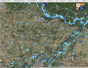
The characteristics of the two satellites are highly complementary. Sentinel-1A provides a complete synoptic spatial coverage of the AOI, while CSK provides high-resolution space/time information on the evolution of the event at sub-areas of specific interest. Regular Sentinel-1A interferometric wide-swath mode acquisitions also allow a reliable, large-scale identification of permanent water bodies (e.g., rivers and lakes). In this case the use of Sentinel-1A acquisitions from the 4th (pre-event) allowed the identification of the Po river, shown in dark blue in Figure 4. The results obtained using Sentinel-1A (left) and CSK (right) show good agreement.
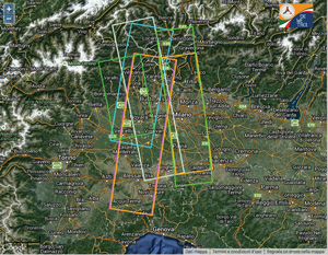
Spatial and temporal coverage of the AOI by Sentinel-1A (top) and CSK (bottom) for the period November 13–20, 2014.
Image credit: (top) ESA, Google Maps (bottom) DEWETRA (CIMA), Google Maps
Conclusions
The two cases presented are examples of how the synergistic use of different sources of information can improve the ability to monitor floods using satellites. The Albenga flood case shows how close cooperation between forecaster, end user, data provider, and value adder greatly increases the probability of detecting flash floods. In this case, the probability of successfully identifying flooded areas increased to 50%, compared to a zero probability when using images ordered after the event.
In the second example, the synergistic use of two satellite missions has been shown to produce high added value for flood monitoring. Sentinel-1A was assigned the task of covering the entire event and identifying permanent water bodies. CSK was tasked with providing high-resolution spatial and temporal information about the evolution of the event in areas of specific interest. It is anticipated that the increased revisit frequency following the launch of Sentinel- 1B (down to 6 days) will greatly improve the chances of synoptic spatial coverage of events.
Comparison of the flooded areas derived from Sentinel- 1A (top) and CSK (bottom) at the same time (18:22 local time) on November 16th. The dark blue color indicates permanent water bodies derived from Sentinel-1A.
Image credit: (top) ESA, Google Maps (bottom) ASI, Google Maps. Click to enlarge.
Case study contributors
Giorgio Boni, Luca Pulvirenti, Francesco Silvestro, Giuseppe Squicciarino (CIMA Research Foundation)
Paola Pagliara, Roberta Onori, Chiara Proietti (Italian DPC)
Laura Candela, Anna Rita Pisani, Simona Zoffoli (ASI)
Acknowledgements
The authors thank the Liguria region for providing flood forecasts for the rivers Centa, Entella, and Magra. The figures were made using the open source platform DEWETRA of the DPC. The feasibility study for the COSMO-SkyMed acquisitions was conducted using the NFS platform, developed by Acrotec s.r.l. and co-funded by ASI (Bando periodico riservato alle PMI, Bando Tematico N. 02 “Osservazione della terra”)