Imaging Multi–spectral Radiometers (Passive Microwave)
Description
Operating at microwave wavelengths, these instruments have the advantage of cloud penetration and all-weather capability. Channels within 1 GHz to 40 GHz and 80 GHz to 100 GHz are used to get day/night information on Earth’s surface. They have the advantage over visible/IR radiometers of being able to probe the dielectric properties of a surface or penetrate certain surfaces, a capability that is especially useful with vegetation, soil, sea ice and snow. Observations by instruments like AMSU-A, with channels between 50 GHz and 60 GHz, have been used for deriving atmospheric parameters, especially atmospheric temperature.
Like other microwave instruments, these passive instruments offer accurate spectral information but their spatial resolution is poor. At 90 GHz, their spatial resolution is typically 5 km, and for the lower frequencies it is of order tens of kilometres – poorer than that of their visible or infrared counterparts. As a consequence, they are most used for global analysis rather than regional or local, although some instruments are used to correct measurements from other sensors, rather than for imaging applications. These include the microwave radiometers on the ERS/Envisat (ended 2012) and Topex/Poseidon/Jason series of satellites, which are used to estimate and correct for atmospheric water vapour content in the column through which altimetric readings are being taken.
Applications
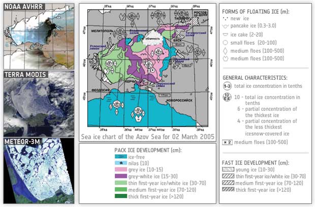
Measurements from these instruments may be used to infer a range of atmospheric and Earth surface parameters. One of their primary uses (often in conjunction with other instruments) is snow and ice mapping, due in part to their capability for cloud penetration and their ability to take measurements during daytime and night time. Current applications of passive microwave radiometer data include operational forecasting and climate analysis and the prediction of sea-ice concentration, extent and ice type. Passive microwave radiometers are also used to provide information on the liquid water content of clouds (e.g. the GPM mission).
|
 |
| |
|
|
| Current & planned instruments |
| Advanced MTVZA |
|
L-band Radiometer (SMAP) |
|
|
| AMR |
MADRAS |
|
|
| AMSR-2 |
MIRAS |
|
|
| AMSR-E |
MIRAS (SMOS) |
| Aquarius L-band radiometer |
MTVZA |
|
|
| GeoSTAR |
MWI-Cloud |
|
|
| GMI |
MWI-Precip |
|
|
| ICI |
MWRI |
| IRS (SJ-9B) |
RAD |
| JMR |
SSM/I |
|
|
| K-band radiometers (SCLP) |
TMI |
|
|
|
|
|
|
|
|
|
|
These instruments can also supply some information on soil moisture content, which is a key surface parameter in agriculture, hydrology and climatology, and provides a measure of vegetation health. Furthermore, they are capable of contributing some information on ocean salinity, which is important to our understanding of ocean circulation. Developing these capabilities is a current research task.
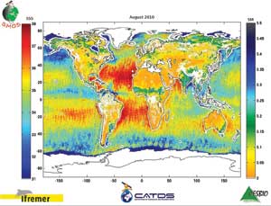
First-ever global map of sea-surface salinity and soil moisture produced with the same instrument on ESA’s SMOS satellite.
|
|