Lightning instruments
Description
Lightning is a valuable indicator for convective activity in climatology and on the cloud scale, and is correlated with storm-related phenomena such as precipitation, hail and gust. Lightning strikes are also associated with a number of risks to human activities. Before the advent of satellite observations, global lightning patterns were known only approximately. Ground-based radio-frequency sensors provide high-quality local measurements, but because such sensors have a limited range, oceans and low-population areas had been poorly sampled. The development of space-based lightning sensors was a major advance, giving researchers a more complete picture of planet-wide lightning activity.
Satellite detection of lightning is based on the use of optical sensors that use high-speed cameras focused on the cloud tops. By analysing a narrow wavelength band around 777 nm in the near-infrared region, brief lightning flashes can be detected even under daytime conditions. To date, satellite lightning observations have only been made from low-Earth orbit platforms, and have mostly been focused on proving the science, and on technology development. For example, NASA’s Lightning Imaging Sensor (LIS) on the Tropical Rainfall Measuring Mission mission, which has been operating since 1997.
Now that lightning detection from low-Earth orbit has been proven, a number of missions are being planned to move monitoring an operational basis from geostationary platforms. This includes missions from major meteorological agencies such as NOAA, EUMETSAT and NSMC-CMA.
Advantages of the geostationary perspective in lightning detection include:
− Enabling observations of a total hemisphere with location accuracy of about 8-10 km and estimated detection efficiency of 60-90%;
− Observation of a storm through its whole life cycle; and
− Detection of total lightning including cloud-to-ground and intra-cloud lightning is detected. Intra-cloud lightning is about an order of magnitude more frequent than cloud-to-ground lightning.
Applications
Lightning location data are used widely in research, as well as in various application areas. Real-time data are used operationally for forecast and warning services, for example weather services, power utilities, aviation and wildfires. While archived data are used for applications like insurance, climatology and other research activities.
|
 |
| |
|
|
| Current & planned instruments |
|
|
Thunderstorms can be identified and characterised using cloud-observing satellites and ground radar, with cloud observing satellites providing products with a spatial resolution of 5 km and a sampling rate of 30 minutes, while ground radar provide spatial resolution of 100 m – 2 km and a sampling rate of 10-20 minutes. Lightning data can then be layered on top of these observations to indicate the most active parts of the storm clouds; help narrow identification of potentially hazardous regions; and, because of coming real-time availability from geostationary satellites, can be employed to bridge gaps between successive cloud satellite and ground radar samples.
Lightning density is also well correlated to rainfall rates, with a high lightning rate a reliable indicator of heavy precipitation. This is of particular use in areas where ground-based radar is not available or obstructed, for example in mountainous regions where heavy precipitation can be followed by flash floods.
In addition to real-time and forecast applications, the synoptic nature of satellite lightning detection enables the tracking of patterns over time. For example, in the northern hemisphere, most lightning happens during the summer months. But in equatorial regions, lightning appears more often during the autumn and spring. Understanding seasonal variations such as this contributes to the understanding lightning’s role in phenomena such as wildfires, and could be used to monitor changes in the climate.
Our increasing reliance on electronic devices, both industrially and in the consumer sphere, also increases our exposure to the risk of lightning strike. Real-time information on lightning activity can be a valuable tool for the management of large-scale electrical utilities and grids, allowing operators to optimise operations and minimise the potential for damage by rerouting operations.
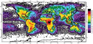
Data from space-based optical sensors reveal the uneven distribution of worldwide lightning strikes. Units: flashes/km2/yr. (Credit: NASA)
|
|