Atmospheric Temperature and
Humidity Sounders
Description
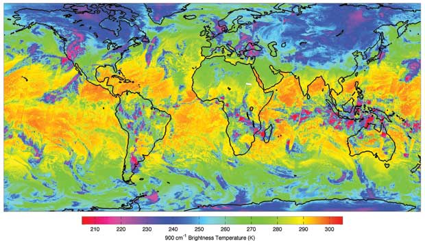
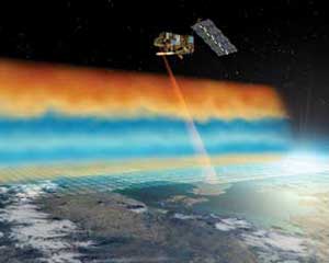
Atmospheric sounders generally make passive measurements of the distribution of infrared (IR) or microwave radiation emitted by the atmosphere, from which vertical profiles of temperature and humidity through the atmosphere may be obtained. Oxygen or carbon dioxide is usually used as a ‘tracer’ for the estimation of temperature profiles, since they are relatively uniformly distributed throughout the atmosphere, so atmospheric temperature sounders often measure radiation at wavelengths emitted by these gases. For humidity profiling, either IR or microwave wavelengths specific to water vapour are used. Most measurements are conducted in nadir- viewing mode.
Sounders are able to estimate profiles of temperature and humidity by identifying radiation coming from different levels in the atmosphere. This is achieved by observations of the spectral broadening of an emission line, a phenomenon primarily caused by intermolecular collisions with other species and which decreases with atmospheric pressure (a function of altitude).
Microwave sounders have the ability to sound through cloud and hence offer nearly all-weather capability. However, their spatial resolution (both vertical and horizontal) is generally lower than that of the IR instruments. IR sounders are routinely used to provide temperature profiles from a few km altitude to the top of the atmosphere with a temperature accuracy of 2–3K, a vertical resolution of around 10 km, and a horizontal resolution of between 10 km and 100 km.
The latest generation of sounders, combining IR (AIRS, IASI, CrIS) and microwave (MHS, ATMS) capabilities feature improved accuracy of humidity and temperature measurements (of order 10% accuracy for humidity and below 1K for temperature); better spatial resolution (to 1 km); and improved capabilities in the upper atmosphere.
Observations of how the signals from Global Positioning System satellites are affected as they travel through the atmosphere will be increasingly exploited, using a technique known as GPS occultation. This technique is used to determine profiles of the pressure, temperature and humidity, and will provide complementary information.
 |
 |
| |
|
|
| Current & planned instruments |
| Advanced Radiomet |
|
Lagrange |
|
|
| AIRS |
MHS |
|
|
| AMSU-A |
MLS (EOS-Aura) |
|
|
| AMSU-B |
MWAS |
|
|
| ASI |
MWHS |
|
|
| ATMS |
MWHS-2 |
|
|
| ATOVS |
MWS |
|
|
| (HIRS/3 + AMSU + AVHRR/3) |
MWTS |
|
|
| CrIS |
MWTS-2 |
|
|
| GNOS |
Radiomet |
|
|
| GOLPE |
ROSA |
|
|
| GOX |
ROSA |
|
|
| GPSRO (Oersted) |
ROSA |
|
|
| GPSRO (Terra-SAR) |
SAPHIR |
|
|
| GRAS |
SMR |
|
|
| HIRS/3 |
Sounder |
|
|
| HIRS/4 |
Sounder (INSAT) |
|
|
| HSB |
SSM/IS |
|
|
| IASI |
SSM/T-1 |
|
|
| IASI-NG |
SSM/T-2 |
|
|
| IKFS-2 |
TANSO-FTS |
|
|
| IMWAS |
TANSO-FTS-2 |
|
|
| IRAS |
TOU/SBUS |
|
|
| IRS |
|
|
|
Applications
Since the launches of the first weather satellites in the 1960s, atmospheric sounders have provided valuable global observations of the atmosphere, even in the remotest areas. In 1969, the first temperature profile information estimated from satellite measurements was introduced into the Numerical Weather Prediction (NWP) models that are at the heart of daily weather forecasts. Even in those early days the new satellite measurements improved forecasts significantly for many areas once the challenges of data assimilation were addressed, initially in the Southern Hemisphere and later in the Northern Hemisphere.
Today, atmospheric sounders are used to infer a wide range of key atmospheric parameters on an operational basis (mostly on polar-orbiting satellites), and their data are used by NWP models to such an extent that the satellite measurements are a vital and integral part of the global observing systems for operational meteorology. They also provide measurements of sea-surface temperature, albedo, aerosols, trace gases, precipitation, snow, ice, major fires and more, with frequent global coverage. Whilst these measurements do not usually have the highest spatial resolution or accuracy, they are important sources of information and can be combined with the accurate, but more limited coverage, provided by specialist instruments. These measurements of other variables are also important in allowing the generation of records of some variables extending back some 30 years. The same data are used for studies of extended weather and climate forecasting, and detection of climate change, including human-made change.
|
|