Gravity, Magnetic Field and Geodynamic Instruments
Description
This category of instruments is used here to describe a variety of sensors and supporting systems used to derive information on Earth’s gravity field, magnetic field or geodynamic activity.
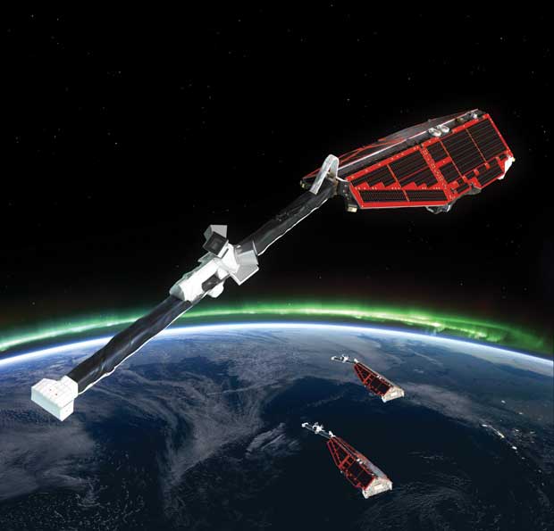
Gravity field measurements from space rely on one of three techniques:
— Use of single or multiple accelerometers on one or more satellites to derive gravity or gravity-gradient information;
— Precise satellite orbit determination (using satellite-to-ground navigation systems such as GPS and satellite laser ranging systems), and separation of satellite motion, induced by Earth’s gravitational force alone, from other forces (such as solar radiation and aerodynamic drag);
— Satellite-to-satellite tracking (e.g. by GPS or microwave link) to measure relative speed variations of two satellites induced by gravitational forces.
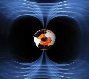
Satellite-borne magnetometers provide information on the strength and direction of Earth’s internal and external magnetic field and its time variations.
Applications
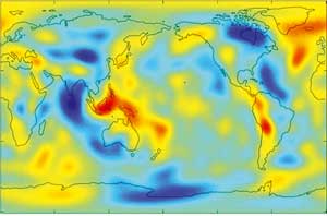
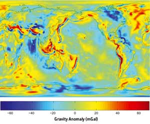
Gravity field measurements from space provide the most promising advances for improved measurement of the ‘geoid’ and its time variations. The geoid (the surface of equal gravitational potential at mean sea level) reflects the irregularities in the Earth’s gravity field at the surface due to the inhomogeneous mass and density distribution in the planet’s interior.
More accurate models of the static mean geoid and its temporal variability are vital for:
— A precise marine geoid, needed for the quantitative determination, in combination with satellite altimetry, of absolute ocean currents, their transport of heat and other properties;
— A unified global height reference system for the study of topographic processes, including the evolution of ice sheets and land surface topography;
— New understanding of the physics of Earth’s interior;
— Estimates of the thickness of the polar ice sheets and their variations through a combination of bedrock topography derived from gravity measurements and ice sheet surface topography from altimetry; |
 |
| |
|
|
| Current & planned instruments |
| Gravity |
|
Precision orbit |
|
|
| EFI |
ACC |
|
|
| EGG |
DORIS-NG |
|
|
| GRACE instrument |
DORIS-NG (SPOT) |
|
|
| LRI |
EGG |
| MWI |
GOLPE |
| |
GPS (ESA) |
|
|
| Magnetic field |
GPS Receiver (Swarm) |
|
|
| Advanced GGAK-M |
GPSP |
|
|
| ASM |
GRAS |
|
|
| CSC FVM |
INES |
|
|
| GGAK-E |
IST |
|
|
| GGAK-M |
Laser Reflectors |
|
|
| Magnetometer (NOAA) |
Laser Reflectors (ESA) |
|
|
| MMP |
LCCRA |
|
|
| Overhauser Magnetometer |
LRA |
|
|
| SSJ/4 |
LRA (LAGEOS) |
|
|
| SSJ/5 |
LRR |
|
|
| SSM |
ROSA |
|
|
| VFM |
RRA |
|
|
| SI |
|
| SSTI |
|
| STR |
|
| TDP |
|
|
|
|
|
|
|
— Estimates of the mass/volume redistribution of fresh water in order to further understand the hydrological cycle;
— Improved understanding of post-glacial rebound processes on a global scale.
Magnetic field measurements are also valuable in a range of applications, including navigation systems, resource exploration drilling, spacecraft attitude control systems, assessments of the impact of ‘space weather’ caused by cosmic particles and earthquake prediction studies.
The precision location capabilities of satellite laser ranging and other systems (such as DORIS and GPS), sometimes in combination with interferometric SAR (INSAR), are applied in support of studies of crustal deformation, tectonic movements and Earth’s spin rate.
|
|