Imaging Multi–spectral Radiometers (visible/IR)
Description
Visible/IR imaging multi-spectral radiometers are used to image Earth’s atmosphere and surface, providing accurate spectral information at spatial resolutions of order 100 m up to several km, with a swath width generally in the range several hundred to a few thousand km.
In addition, these observations can be used to study critical components of the water cycle, such as cloud macro- and micro-physical properties, from which information on atmospheric dynamics and pollutants can be determined.
The information obtained from these instruments is often complemented by that from atmospheric sounders, since atmospheric effects such as absorption must be taken into account in deriving parameters such as surface temperatures.
Recent developments include improvements in spatial resolution (which, in some cases, is equivalent to those of high-resolution imagers), spectral resolution, radiometric accuracy and multi-angle capability. Planned hyperspectral instruments that will be able to simultaneously acquire imagery in many tens of wavebands should significantly improve the quality of land cover and land use information derived from satellite imagery.
Applications
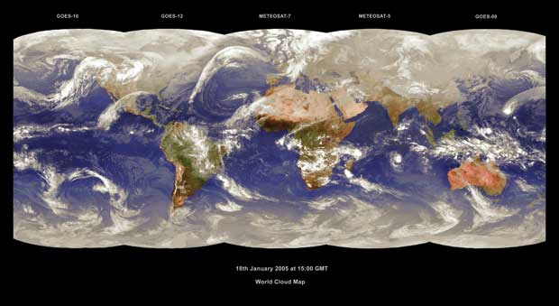
Measurements from these multi-spectral radiometers operating in IR and visible bands may be used to infer a wide range of parameters, including sea and land surface temperatures, snow and sea ice cover, and Earth’s surface albedo. These instruments may also make measurements of cloud cover and cloud top temperatures. Measurements of the motion vectors of clouds made by radiometers on geostationary satellites may be used in order to derive tropospheric wind estimates. Accurate information on atmospheric dynamics, derived from the instruments mounted on geostationary meteorological satellites like GMS, GOES or Meteosat, is essential for precise short- and medium-term weather forecasts provided by NWP centres in Japan, the US and Europe.
Visible/IR radiometers are an important source of data on processes in the biosphere, providing information on global vegetation and its variations on sub-seasonal scales. This allows monitoring of natural, anthropogenic, and climate-induced effects on land ecosystems. Observations by AVHRR on NOAA and MetOp are traditionally used to provide classification and seasonal monitoring of global vegetation types, allowing estimation of primary production (the growth of vegetation that is the base of the food chain) and terrestrial carbon balances. Such information is of great value in supporting the identification of drought areas and provides early warning of food shortages.
|
 |
| |
|
|
| Current & planned instruments |
| ABI |
|
MERSI-2 |
|
|
| Advanced KMSS |
METimage |
|
|
| Advanced MI |
MI |
|
|
| Advanced MSU-MR |
MIRS |
|
|
| AHI |
MMRS |
|
|
| ALISS III |
MODIS |
|
|
| AVHRR/3 |
MS |
|
|
| AWFI |
MS (GISTDA) |
|
|
| AWiFS |
MSI (EarthCARE) |
|
|
| CCD (ZY-02C and ZY-3) |
MSU-GS |
| CCD camera |
MSU-MR |
|
|
| CHRIS |
Multi-spectral thermal infrared imager (HyspIRI) |
|
|
| EPIC |
MUX |
|
|
| ETM+ |
MUX (ZY-3) |
|
|
| FCI |
MVIRI |
|
|
| HRMX |
MVIRS |
|
|
| HRMX-TIR |
MX (Cartosat-3) |
|
|
| HRMX-VNIR |
NigeriaSat Medium Resolution |
|
|
| HRTC |
NIRST |
| HSC |
OLCI |
|
|
| HSC |
OLI |
|
|
| HSI |
OLS |
| HSI (HJ-1A) |
PCWMP |
|
|
| HSTC |
RASAT VIS Multispectral |
|
|
| HYC |
RASAT VIS Panchromatic |
|
|
| Hyperion |
SEVIRI |
|
|
| HySI (Cartosat-3/3A) |
SGLI |
|
|
| HYSI-SWIR |
SLSTR |
|
|
| HYSI-VNIR |
TANSO-CAI |
|
|
| IIR |
TANSO-CAI-2 |
|
|
| IR (HJ-1B) |
TIR (Oceansat-3/3A) |
|
|
| Imager |
TIRS |
|
|
| Imager (INSAT) |
VEGETATION |
|
|
| IMAGER/MTSAT-2 |
VHRR |
|
|
| IR Correlation Radiometer (GeoCape) |
VIIRS |
|
|
| IRS |
VIRR |
|
|
| IVISSR (FY-2) |
VIRS |
|
|
| JAMI/MTSAT-1R |
Visible imaging spectrometer (HyspIRI) |
|
|
| KMSS |
VSC |
|
|
| LEISA AC |
WFC |
|
|
| MCSI |
WFI-2 |
|
|
| MERSI |
|
|
|
|
|
|
|
|
|
|
|
|
|