Imaging Microwave Radars
Description
These instruments transmit at frequencies of around 1 GHz to 10 GHz and measure the backscattered signals to generate microwave images of Earth’s surface at high spatial resolutions (between 10 m and 100 m), with a swath width of 100–500 km. Both synthetic aperture radars and real aperture side-looking imaging radar systems fall into this category. The images produced have a similar resolution to those from high-resolution optical imagers, but radars have the capability to ‘see’ through clouds, providing data on an all-weather, day/night basis.
SARs also have the ability to penetrate vegetation and to sample surface roughness and surface dielectric properties. They may also be used to obtain polarisation information. Although the operating wavelength is generally fixed for a given radar, radars operating at a variety of wavelengths (typically L-, C- and X-band) will be increasingly available during the next decade.
The beam shape and direction of new-generation SARs enable imagery to be acquired more frequently from many points on Earth. Multipolarised SARs (such as ASAR on Envisat) enable land cover to be classified more accurately and will soon provide improved data on biophysical parameters such as soil moisture and biomass.
A number of bistatic radar system concepts are under study. A bistatic radar is a system that operates with separated transmitting and receiving antennas. A number of large active radar missions are foreseen for the coming decade, providing an opportunity to fly relatively small satellite missions with passive payloads in formation with one of these missions in order to gather the backscatter information.
Applications
Although a variety of backscatter measurements may be taken by imaging radars, interpretation of these measurements is a complex science that, in some respects, is still developing. However, significant advances have been made in a number of areas and some SAR applications are now fully operational.
Backscatter from the ocean can be used to deduce surface waves, to detect and analyse surface features such as ocean fronts, eddies and oil slicks, and to detect and track ships from their wakes. Operational wave and sea ice forecasting is also an important near-real time application of SAR data.
Since land images may be used to infer information on vegetation type and cover, they are of use in forestry and agriculture. The ability of SARs to penetrate cloud cover makes them particularly valuable in rainforest studies and resource monitoring applications. The information obtained from such images depends upon the characteristics (e.g. wavelength) of the probing radiation. Under certain conditions, for example, some penetration of vegetation may be feasible. Such imagery is often used in order to complement visible/IR multi-spectral imagery by, in effect, providing an additional microwave channel.
|
 |
| |
|
|
| Current & planned instruments |
| Advanced SAR |
|
SAR (RADARSAT-2) |
|
|
| Arkon-2M SAR |
SAR (RCM) |
|
|
| CSG SAR |
SAR (RISAT) |
|
|
| C-band SAR |
SAR 2000 |
|
|
| COSI |
SAR-L |
|
|
| Ku- and X-band radars (SCLP) |
SAR-X |
|
|
| L-band SAR |
S-band SAR |
|
|
| L-band RADAR (SMAP) |
Severjanin |
|
|
| PALSAR-2 (ALOS-2) |
WSAR |
|
|
| Paz SAR-X |
X-band SAR |
|
|
| SAR |
|
|
|
|
|
One of the most important current applications of imaging radars is in all-weather measurements of snow and ice sheets, from which information on topography and texture may be inferred. Flood detection is another proven capability of SAR.
A technique known as interferometry is used to record the phase shift between two SAR images recorded at slightly different times and viewing angles. This provides accurate information on the motion of surfaces and targets such as sea ice and ice sheets, and allows large-scale 3D topographical images to be produced. Similar stereo images may be produced using conventional SAR images taken on adjacent orbits. Since differential SAR interferometry can detect ground movements at millimetre/sub-millimetre level, it is of interest in the context of tectonic and volcanic hazard studies, and in studies of subsidence in urban areas.
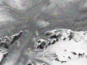
ERS-2/Envisat interferogram of a fast-moving (>1 m/h) glacier in
Greenland.
|
|