Multiple-Direction/ Polarisation Instruments
Description
Advances in satellite instrumentation have resulted in a general trend towards multifunctional capabilities in many types of sensors, resulting in instruments with the capability to operate using different viewing modes and angles, as well as multiple polarisations. The latest SAR instruments demonstrate this trend. The category of ‘multiple direction/polarisation instruments’ is used here, however, to describe instruments that are custom-built for observing the directional or polarisational characteristics of the target’s signature (either visible/IR or microwave), as a means of deriving geophysical information.
Multi-directional radiometers can make observations from more than one incidence angle of the transmitted or diffused radiation emitted by a particular element of Earth’s surface or clouds. In this way, information on anisotropies in the radiation may be identified. The emphasis in these instruments is on spectral (rather than spatial) information, with the result that the detection channels, which typically span the visible to the IR, are precisely calibrated and the spatial resolution is usually about 1 km.
Polarimetric radiometers are used for applications in which radiative information is embedded in the polarisation state of the transmitted, reflected or scattered wave. Some polarimetric radiometers also have a multi-directional capability, so that directional information can be determined or used during retrievals of geophysical parameters.
Applications
Using IR channels, multiple-angle viewing capabilities are used to achieve accurate corrections for the effects of (variable) atmospheric absorption, making it possible to infer precise temperature values, for example, of sea and land surfaces. Multi-directional radiometers are also capable of measuring cloud-cover and cloud-top temperatures, together with atmospheric water vapour and liquid water content.
In the visible and near-IR spectrum, these instruments allow for improved measurements of the scattering properties of particles such as aerosols, as well as measurement of the angular characteristics of the various contributions to Earth’s radiation budget, including surface albedo. |
 |
| |
|
|
| Current & planned instruments |
| MIRAS (SMOS) |
|
Next Gen APS (ACE) |
|
|
| MISR |
POLDER-P |
|
|
| MWR |
|
|
|
They also enable accurate measurement of parameters such as Normalised Difference Vegetation Indices, which are used to assess vegetation state and crop yield at regional and global scales. MISR, currently flying on NASA’s Terra mission, is providing new types of information for scientists studying Earth’s climate, such as the partitioning of energy and carbon between the land surface and the atmosphere, and the regional and global impacts of different types of atmospheric particles and clouds.
Polarisation information is used to infer a variety of parameters, including the size and scattering properties of liquid water, cloud particles and aerosols, while providing additional information on the optical thickness and phase of clouds. Polarimetric radiometers also provide information on the polarisation state of the radiation backscattered from Earth’s surface, supplementing measurements obtained from other land- and sea-imaging instruments. Such measurements are of interest in a range of applications, from investigations of albedo and reflectance to agriculture and the classification of vegetation. ESA’s SMOS mission, launched in late 2009, uses an L-band (1.4 GHz) microwave interferometer to measure estimates of soil moisture (a key variable for numerical weather and climate models) and ocean surface salinity (important for ocean circulation and sea level models).
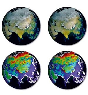
Seasonal changes in Earth’s surface albedo as measured by the MISR instrument on the Terra mission.
|
|