More than 40 nations are identified as having invested in EO satellites, amounting to government investment of approximately US$7-8 billion per annum, with further and increasing investment coming from the commercial sector and through public-private partnerships. Many of the biggest programmes are moving to free and open data policies, so that the data generated by this valuable infrastructure might be applied without restriction and across a whole range of societal benefit areas. The Copernicus programme of the European Commission (EC) and European Space Agency (ESA) will provide free and open access to a range of data types, both optical and radar, of direct value to DRR – amounting to thousands of images per day (equivalent to approx. 1250 DVDs of data per day). Similarly, the satellite EO programmes of the US government are operated on the basis of free and open access to data. Since the Landsat programme archive was opened in this way in 2008, some 20 million scenes have been downloaded by users all around the world.
These investments have been made with a view to numerous and diverse applications of the space-based infrastructure and the observing capabilities of the hundreds of satellites involved. Many of these satellites
have substantial potential to contribute to DRM, including DRR. Indeed, for a few satellites, DRM is one of their primary functions; but for most it is a great potential that is yet to be fully realised.
As with satellite communications and satellite navigation systems, the use of a space-based infrastructure for the provision of EO in support of disasters provides several benefits:
– The infrastructure is not vulnerable to the disaster itself; surface-based infrastructure like in-situ sensors and communication systems are prone to damage and failure as a result of disasters, whereas satellites offer a robust source of near-real time and unique information to aid disaster management;
– Consistent and comparable information is collected systematically on multiple scales, from local to trans- boundary to global;
– Inaccessible and hazardous areas can be sensed without risk, including at all stages of disaster management.
Satellite observations can supply regular, detailed updates on the status of hazards on a global, regional, or national basis. EO satellite data are a complementary data source to in-situ data (as well as airborne data, socio-economic data, and model output) in many countries, but in some cases it may be the only source of information, either because of limited or lacking in-situ information or because satellites offer a unique means of monitoring that cannot be affected by the hazards observed.
More than a hundred EO satellites are in operation at any one time, hosting a diverse range of sensor types that utilise different parts of the electromagnetic spectrum and different techniques to provide a range of measurements from space. Much of these data are available freely and openly for any purpose and ready for application by the DRR community.
Some of the measurements are undertaken from geostationary orbit whereby the satellite is always above the same spot on the Earth and effectively sees a full ‘disc’ view of the Earth. These are typically for meteorology purposes and are the source of the familiar weather pictures shown on TV news. Most EO satellites orbit the Earth over the poles and collectively offer daily access to most points on the globe for both optical and radar imagery.
These satellites are closer to the Earth’s surface and can typically provide data at a higher resolution and accuracy than meteorological satellites.
Measurements from these satellites provide valuable additional input that can be used for a multitude of applications in support of disasters: tracking the path of tropical storms including typhoons, cyclones and hurricanes worldwide; monitoring changing morphology of volcanic domes in case of eruptions; tracking the dispersion of ash emitted during volcanic eruptions; mapping the geographical extent of flooded regions even under cloudy conditions; tracking the extent of forest fires and oil spills; and monitoring the effects of droughts on soils, vegetation, and crops.
As the United Nations plans for the post-2015 framework to succeed the HFA, satellite data have a critical role to play, particularly in providing information to help reduce the underlying risk factors and strengthening disaster preparedness for effective response in association with traditional methods used by the DRM community.
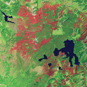
This 1989 image from Landsat 5 shows the extent of fire burnt area (in red) following severe fires in Yellowstone National Park.
Image credit: NASA Earth Observatory, Robert Simmon,
United States Geological Survey.
Satellite EO Contributions
Satellite EO contributes primarily to the hazard and exposure components of DRR and to the following functions in particular:
– Exposure mapping to support preparedness/mitigation, early warning & response. Basic mapping underpins almost all the mapping services provided in disaster management and humanitarian aid projects using satellite EO. It provides the base layer information that users can utilise to determine key geographical attributes of a given area. Significant archives of satellite data exist, from as far back as the 1970s in some cases, that can be mined for baseline information of various kinds;
– Hazard mapping and risk assessment (geo-hazards, hydro-meteorological hazards, climatological hazards, technological hazards). For example, flood risk analysis provides information to support risk management and water resources management. Different types of information can be extracted, such as the classified distribution of the land cover and socio-economic units in areas at risk or hazard damage information based on measurements of water depth and/or flow velocity.
– Again, the satellite archives can provide historical data that contribute to hazard assessment, such as historical flood extents for major events over a given area;
– Critical infrastructure monitoring. Up-to-date, synoptic, and objective infrastructure information helps maintain a current status concerning assets at risk. Such data can be used to provide improved knowledge of the potential impact of natural hazards in areas at risk. For example, repeat satellite radar images can be used to measure sub-centimetre-scale changes in deformation over spans of days to years, with applications for geophysical monitoring of subsidence and structural stability;
– Early warning/alert and tracking of a range of natural hazards, including tropical cyclones, landslides, and volcanoes;
– Disaster response following natural and man-made hazards and support for Crisis Mapping/Damage Assessment, including rapid assessment and the location, scale and severity of the disaster impact;
– Support to recovery/reconstruction/rehabilitation. Satellite EO supports precise post-disaster needs assessment and evaluation of early and long-term recovery needs and priorities; this includes use to position recovery aid, identify safe and unsafe areas, prioritise infrastructure repair, monitor risks from repeat hazards, development of a spatially explicit timeline of recovery, and informing the direction of reconstruction aid.
How Satellite EO Helps
The language that has been developed in support of WCDRR, the post-2015 framework for disaster risk reduction, and the topic of DRR, identifies risk as a function of:
– Hazard – an act or phenomenon that has the potential to produce harm or other undesirable consequences to a person or thing;
– Exposure – the people, property, systems, or functions that could be lost to a hazard. Generally exposure includes what lies in the area the hazard could affect;
– Vulnerability – susceptibility to physical injury, harm, damage, or economic loss. It depends on an asset’s construction, contents, and economic value of its functions.
Satellite EO supports a wide range of disaster types and all phases of DRM, including the very long term monitoring of climate phenomena. Part II of this document provides some real and practical examples of the different ways satellite EO is being applied by governments, disaster agencies, and UN bodies around the world in support of DRR.
Part III provides an overview of the contribution of satellite EO to the different phases of disasters, with a focus on the benefits to the end users. Until relatively recently, most of the activity around the application of satellite EO focussed on the immediate response phase. The DRM community, including engaged space data providers, has in recent years increased the emphasis on Disaster Risk Reduction, recognising that more lives can be saved and property can be better protected through proactive investment in risk reduction or mitigation.
Satellite EO can help science in narrowing down the uncertainty in hazard and risk assessment and supports better informed practitioners and end users. Satellite EO also assists in educating the general public around a culture of disaster prevention and resilience.
Satellite EO can support indicators to monitor progress in the implementation of DRR and support harmonisation of international standards and risk assessment practices, especially when hazards are trans-boundary in nature. It can help augment the capacity of the community to manage risks.
A number of national DRM-related agencies have already adopted satellite EO in their formal guidelines for risk mitigation, and acquire EO data routinely on a nationwide basis.
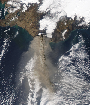
The ash plume generated by the eruption of Eyjafjallajökull volcano in Iceland, as seen by the Moderate Resolution Imaging Spectroradiometer (MODIS) on NASA’s Aqua satellite.
Satellite EO helped track the spread of volcanic ash, assisting aviation safety decision-makers. Around 100,000 flights were cancelled due to the eruption, resulting in losses of approximately 200 million US/day.
Image credit: NASA Earth Observatory, Jeff Schmaltz, MODIS Rapid Response Team (NASA).
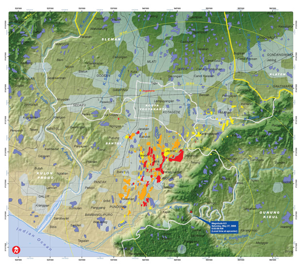
Preliminary damage assessment and critical infrastructure map for Java Island, Indonesia, following a magnitude 6.3 earthquake on Saturday May 27, 2006.
Image credit: UNITAR/UNOSAT
International Coordination
Technologies such as satellite EO do not themselves result in reduced damage or losses, but their use facilitates better- quality decisions that can bring this about. The significant investment in space-based infrastructure has not yet been fully exploited for DRR. Realising the full benefits requires a solid base of political support, laws and regulations, institutional responsibility, and trained people.
A number of international coordination efforts have been pioneering the establishment of the necessary connections between data providers, information developers, and end users to ensure that decision-makers in the DRM community are able to benefit from satellite EO.
The International Disaster Charter
The International Charter on Space and Major Disasters is the main mechanism globally by which countries can access satellite EO in support of their disaster response activities. The Charter (www.disasterscharter.org), is an international collaboration among space agencies to provide a unified system to access imagery for disaster response.
With 15 members today, the Charter is able to provide rapid access to data from a virtual constellation of a series of satellites, both optical and radar, tasked in rush mode to help disaster management centres in relief actions. It is
aimed to help better organise, direct, and mobilise national disaster management resources during emergencies and the international relief community concerning situations where humanitarian assistance is required.
The Charter is focused on hazards with rapid onset scenarios, on the hazard impact, and aims to service operational users during the immediate response phase. The Charter provides access to satellite data globally and at no cost to Authorized Users.
Part II of this document features a case study on the Charter.
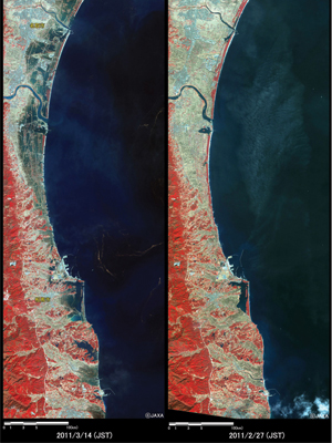
These images from JAXA’s ALOS radar satellite were taken before (right) and after (left) the Great East Japan Earthquake and subsequent Tsunami. Areas flooded by water appear dark blue in the post-disaster image.
JAXA conducted emergency observations using ALOS to generate maps showing damage-area extent and severity, which helped responders search for survivors and coordinate recovery efforts.
Image credit: JAXA
Sentinel Asia
Sentinel Asia is a voluntary basis initiative (www.aprsaf. org/initiatives/sentinel_asia) led by the Asia-Pacific Regional Space Agency Forum (APRSAF) to support disaster management activity in the Asia-Pacific region by applying geospatial information and technologies, including EO satellite data. Its main activities include:
– Emergency observation by EO satellites in case of major disasters (with working links to the Charter as required);
– Acceptance of observation requests;
– Wildfire monitoring, flood monitoring and glacier lake outburst flood monitoring;
– Capacity building for utilization of satellite image/data for disaster management.
The Committee on Earth Observation Satellites
The Committee on Earth Observation Satellites (CEOS) coordinates civil space-based EO programmes. More than 30 national/regional space agencies participate in CEOS coordination efforts, with these agencies collectively responsible for the operation of more than 100 current EO satellite missions.
The governments and agencies represented in CEOS have resolved to increase application of their investments in EO satellites to the global challenge of DRR. Section 3 of this document explains these in more detail, including the establishment of a Working Group dedicated to Disasters, and the progress of several thematic pilots supporting DRR.
An InSAR image of the northern coast of Norway from Sentinel-1A in August 2014. InSAR images can detect small surface changes and are used for nationwide rockslide hazard mapping by Norwegian authorities. The unprecedented coverage offered by Sentinel-1 will significantly increase the value of InSAR data for this purpose.
Image credit: ESA
Copernicus
In Europe, the EC, through the Copernicus programme, has established the Emergency Management Service (http:// emergency.copernicus.eu) that integrates satellite data with operational value-adding services to support DRM and is currently developing new applications using satellites through its Framework Programmes for Research and Technical Development and in particular its new Horizon 2020 programme of the EU for research and innovation.
Copernicus Emergency Management Service addresses, with worldwide coverage, a wide range of emergency situations resulting from natural or man-made disasters. It covers in particular floods, earthquakes, landslides, severe storms, fires, technological disasters, volcanic eruptions, humanitarian crises, and tsunamis. There have been 95 ‘rush-mode’ activations of the Service since its inception in 2012.
The Group on Earth Observations
The Group on Earth Observations (GEO) is coordinating efforts to build a Global Earth Observation System of Systems (GEOSS). GEO was established in February 2005 by the Third Earth Observation Summit in Brussels. This followed calls for action by the 2002 World Summit on Sustainable Development and the Group of Eight (G8) leading industrialised countries. GEO is a voluntary partnership of governments and international organizations. It provides a framework within which these partners can develop new projects and coordinate their strategies and investments.
GEO addresses multiple societal benefit areas, including disasters. GEO aims to enable the global coordination of observing and information systems to support all phases of the risk management cycle associated with hazards (mitigation and preparedness, early warning, response, and recovery).
GEO provides an important forum for cooperation among space agencies, in-situ observations providers, governmental users, and Ministers.
World Meteorological Organization
The World Meteorological Organization (WMO) is a specialised agency of the United Nations. It is the UN system’s authoritative voice on the state and behaviour of the Earth’s atmosphere, its interaction with the oceans, the climate it produces, and the resulting distribution of water resources. WMO has a membership of 191 Member States and Territories.
The WMO Global Integrated Observing System (WIGOS) enables the collection of data from 17 satellites, hundreds of ocean buoys, thousands of aircraft and ships, and nearly 10,000 land-based stations. Along with the communication and data-processing and forecasting systems of WMO, these observing assets are deployed in support of a range of DRR activities, including:
– The Tropical Cyclone Programme, which uses six Tropical Cyclone Warning Centres dedicated to providing tropical cyclone analysis, forecasts and alerts in support of National Meteorological and Hydrological Service operational warnings;
– International Airways Volcano Watch, which comprises international ground-based networks, global satellite systems, and in-flight air reports to detect and observe volcanic eruptions and ash cloud and pass the information quickly to appropriate air traffic services units and Meteorological Watch Offices, which provide the necessary warnings to aircraft before or during flight. The warnings are based on advisory information supplied by nine Volcanic Ash Advisory Centres designated upon advice from WMO;
– The WMO Programme of Emergency Response Activities, established in 1986 to assist governments to respond effectively to environmental emergencies with large- scale dispersion of airborne hazardous substances from nuclear facility accidents, smoke from large fires, volcanic ash, dust and sand storms, and chemical releases from industrial accidents.
WMO’s close relationship with responsible national agencies ensures effective dissemination of hazard alerts in each case.
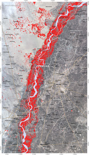
This map of Multan area, Punjab Province (Pakistan) was generated using Landsat-8 and TerraSAR-X data supplied under the International Charter on Space and Major Disasters. Red denotes areas that are affected by flooding.