CEOS is the Committee on Earth Observation Satellites, created in 1984 in response to a recommendation by a Panel of Experts on Remote Sensing from Space, under the aegis of the G-7 Economic Summit of Industrialised Nations Working Group on Growth, Technology and Employment.
CEOS was established to provide coordination of the Earth observations being provided by satellite missions, recognising that no single programme, agency, or nation can hope to satisfy all of the observational requirements that are necessary for improved understanding of the Earth System. Since its establishment, CEOS has provided a broad framework for international coordination on space- borne EO missions.
CEOS has three primary objectives:
– To optimize the benefits of space-based EO through cooperation of CEOS Agencies in mission planning and in the development of compatible data products, formats, services, applications and policies;
– To serve as the focal point for international coordination of space-based EO activities;
– To encourage complementarity and compatibility among space-based EO systems and the data received from them.
CEOS membership had reached 31 space agency Members in 2015, comprising most of the world’s civil agencies responsible for EO satellite programmes.
What Does CEOS Contribute to DRR?
CEOS is working with the user community at local/national and regional levels, with academia, civil protection, UN agencies, and operational resources management agencies to demonstrate the value of EO satellite data and to demonstrate the necessary connections required with the users of the information, as well as the many intermediary bodies.
CEOS has been actively expanding its support to all phases of DRR, building on its original emphasis on disaster response. This resolve is demonstrated through a number of important initiatives:
– Development of a CEOS DRM strategy and supporting Disasters Working Group;
– Establishment of three thematic pilots, covering Floods, Seismic Hazards, and Volcanoes to demonstrate an expanded coordination of space agencies in support of national users of the resulting information products;
− The creation of a Recovery Observatory that showcases how space agencies can improve collaboration with all DRR stakeholders in the aftermath of a major disaster on the scale of Typhoon Haiyan or the Haiti Earthquake of 2010;
− Support to the Geohazard Supersites and Natural Laboratories initiative of GEO. This project coordinates EO acquisitions over designated ‘supersites’ to ensure science users have information required to advance state-of-the-art research into EO-based risk assessment in relation to specific hazards: the volcanoes of Hawaii, four volcanoes in Iceland, the Marmara region Fault Zone in Turkey, and the volcanoes of Italy, New Zealand, and Ecuador. Eventually, the supersites project is expected to develop methodologies that can be used to monitor such hazards using EO on a global basis.
The long-term vision for the CEOS DRM strategy is:
− Global in scope, but building on strong partnerships at local/national or regional levels;
− User-driven (defined against user information needs and based on the engagement of the diverse user communities involved in DRM);
− Taking account of all relevant EO-based capabilities available or under development.
The pilots represent an important part of the CEOS DRM strategy, with an emphasis on the development of connections between the satellite data providers and national users of the resulting information products.
Flood pilot
The main goal is to demonstrate the effective application of satellite EO to the full cycle of flood management at global and regional/local scales by:
– Integrating existing near-real time global flood monitoring and modelling systems;
– Linking global systems to regional end-to-end pilots that produce high-resolution flood mitigation, warning and response products and deliver flood and flash flood related services in: the Caribbean (with particular focus on Haiti); Southern Africa, including Namibia, South Africa, Zambia, Zimbabwe, Mozambique, and Malawi; Southeast Asia (with particular focus on the lower Mekong Basin and Western Java, Indonesia);
– Developing new end products and services to better deliver flood-related information and to validate satellite EO data and products with end users, including retrospective products working from archived EO flood extent data;
– Encouraging regional in-country capacity building to access EO data and integrate into operational systems and flood management practices.
Seismic Hazards pilot
This pilot is characterised by three main objectives:
– Supporting the generation of globally self-consistent strain rate estimates and the mapping of active faults at the global scale by providing EO radar and optical data and processing capacities to existing initiatives;
– Supporting and continuing the Geohazard Supersites and Natural Laboratories initiative for seismic hazards and volcanoes;
– Developing and demonstrating advanced science products for rapid earthquake response (>Magnitude 5.8).
Volcanoes pilot
The volcanoes pilot exploits the instruments of several EO satellite missions to achieve the following objectives:
– Demonstrating comprehensive monitoring of Holocene- era volcanoes in the Latin American volcanic arc;
– Developing new protocols and products over active volcanoes where EO data collects are already taking place (Hawaii, Iceland, and Italy);
– Demonstrating operational monitoring over a large-scale eruption during 2014–2016.
Only CEOS offers the breadth of membership and sensor platforms to provide the full range of necessary data and coordination capacity to support such a broad-ranging effort that groups end users, practitioners, and satellite operators.
Through the above work, CEOS and its Agencies are committed to fostering the use of EO in support of DRR and to raising the awareness of politicians, decision-makers, and major stakeholders of the benefits of using satellite EO in all phases of DRR.
The 3rd World Conference for Disaster Risk Reduction provides an opportunity for the DRR community to better understand the benefits it can draw from the use of satellite EO and to work with the data provider agencies to help realise the full potential of this significant investment in space infrastructure in support of DRR objectives, including the plan of action outlined in the post-2015 framework for disaster risk reduction.
More information on many of the CEOS DRR activities is provided in the Case Studies of Part II.
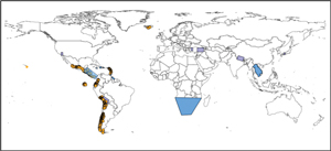
Overview of combined EO data polygons for three CEOS thematic pilots to be deployed over 2014–2016. Floods in blue, seismic hazards in purple, volcanoes in sienna. Areas not to scale and for indicative purposes only. Click to enlarge.
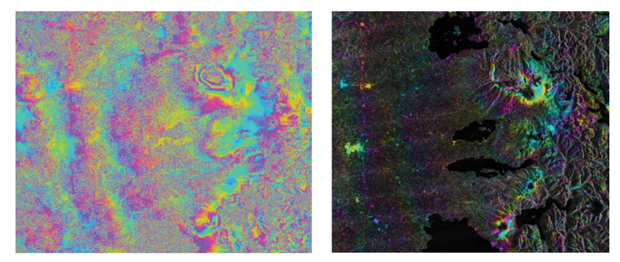
The Cordon Caulle volcano, Chile, erupted in 2011–2012. This interferogram shows post-eruptive inflation that would not otherwise have been known without the CEOS pilot program.