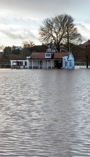
There is growing evidence from models and observations that climate change amplifies the risk factors for extreme weather events, causing more intense tropical storms, heavier rainfalls and flooding, more severe and quicker onset drought, increasing numbers of lightning strikes, and increased conditions for wildfires and dangerous heat waves. The monitoring of long-term trends in climate variability is vital to our understanding of how this intensification will impact weather-related DRM.
With climate models continually evolving in complexity, evaluating the quality and accuracy of their results is critical. Satellites play an essential role here – there is simply no other way to make the globally consistent and comparable observations required to bridge measurements collected on the ground and from planes and ships.
A unified approach to the collection, merging, and analysis of information relating to climate change, sustainable development, and DRR will only be possible thanks to the global datasets collected by satellites.
The Global Climate Observing System
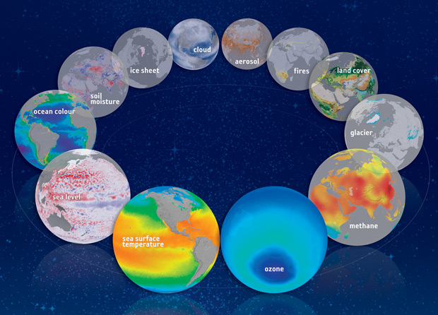
The Global Climate Observing System (GCOS) was established as a long-term, user-driven operational system capable of providing the comprehensive observations required for monitoring the climate system. GCOS has defined 50 ECVs that are technically and economically feasible for systematic observation, in large part due to the capacity of satellites. A detailed global climate record depends critically on a coordinated observing system with a strong satellite component. Of the 50 ECVs identified, 27 are exclusively or largely dependent on satellite observations.development, and DRR will only be possible thanks to the global datasets collected by satellites.
Radiation Budget, Temperature, and Storm Intensity
The Earth Radiation Budget ECV quantifies the overall balance between the incoming energy from the sun and the outgoing energy from the Earth. The radiation balance at the top of the atmosphere is a fundamental driver of the climate system and it can only be measured from space.
The atmospheric and sea-surface temperature ECVs are key predications of climate models and observations are needed to validate the results. Atmospheric temperature observations collected by satellite microwave, infrared, and GPS radio occultation instruments have become key elements of the climate record. When used in combination with aircraft measurements, satellites enable global calibration and scaling to provide a comprehensive record of atmospheric temperatures.
Global sea-surface temperature ECV data sets include a variety of localised measurements from surface drifters, moored buoys, and ships. Satellite measurements enable cross-calibration between these data sources, preserving accuracy while enabling the derivation of globally consistent records.
The Earth’s radiation budget bounds the overall energy balance of the climate system and is reflected in the temperature of the atmosphere and sea surface. In turn these temperatures are linked to the intensity of extreme weather events and the hazards that disaster risk managers need to anticipate and prepare for in the future.
Precipitation and Sea Level
The general view is that the changing climate will drive changes in rainfall patterns, with rainy areas to become wetter, drier areas to become drier, and downpours to become heavier. These changes will have a significant impact on the occurrence of flood disasters. The precipitation ECV is critical to our understanding of these trends.
Observations from surface rain gauge and radar networks lack the density required to create a global record, in particular over the oceans and in countries without radar networks. Satellites can observe rain, ice, and snow and are a key input to constructing long-term, globally consistent records.
Changes in the glaciers and ice caps ECV provide some of the clearest evidence of climate change. Their decline would cause serious impacts on the many societies that are dependent on glacier meltwater, while the resulting sea-level rise would amplify flooding and ocean surge hazards in coastal regions. A century’s-long time series of in situ glacier measurements has been combined with satellite imagery and elevation models to form a comprehensive global record that can be updated at scale as new satellite observations become available.
Sea level ECV measurements from tidal gauges constitute a significant historical climate data record, but local sampling does not enable global coverage. Satellite altimetry provides repeated, consistent, global coverage putting tidal measurements into context and allows data from sites around the world to be directly compared.
Global sea level has been rising for decades and this trend is expected to continue beyond the end of this century. This will expose our densely populated coastlines to increasing risk from flooding and storm surge.