International Charter on Space and Major Disasters
The Charter (see detailed case study in Part II) is a partnership of space agencies that provides a mechanism for the rapid tasking of satellites for immediate response to disasters. It was declared formally operational in 2000 and, as of the end of 2013, has been activated for 402 disasters in 110 countries. The Charter has addressed tropical storms, earthquakes, floods, wildfires, landslides, oil spills, and volcanic eruptions, with different satellite data types better suited to different disaster types. Taken together, the satellites coordinated by the Charter provide global all- weather day-night response capability.
For example during Typhoon Haiyan in November 2013, the strongest ever to hit the Philippines, more than 1,000 high-resolution images were provided freely through Charter activation. These images were used to provide before/after imagery to assess damage to structures, houses, oil facilities, and other infrastructure. They were also used to underpin mapping and analysis in support of situational awareness and for the planning of resource deployment across the many islands of the Philippines. When the tropical storm Haiyan went on to impact the coast of Vietnam, the Charter was again activated to provide a variety of satellite data to produce estimates of affected areas and potential flood and storm inundation risk.
Image credit: Charter on Space and Major Disasters
Flood Mapping
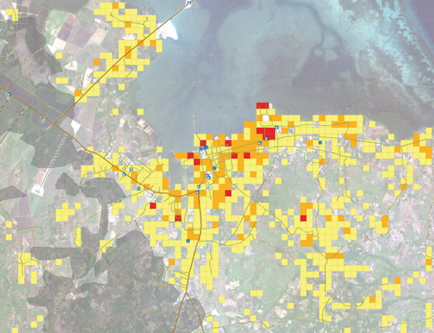
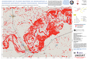
In 2013–2014, the Charter was activated for flood disasters more than once a month on average and accounted for more than half the activations during this period. These activations were spread across the globe, in countries with mature technical capabilities, and in those with very little national capacity to utilise satellite data. In the vast majority of these activations, satellite radar imagery was employed to produce flood-extent maps. Radar imagery enables all-weather, day- night response, which is particularly well suited to the cloudy and rainy conditions associated with flooding, as well as for detecting areas of standing floodwater.
In August of 2013, monsoon rains lead to widespread flooding in the Punjab and Sindh Provinces of Pakistan, where over 130 people were reported killed and government reports indicate that as many as 1 million may have been affected. During the floods, multiple assessments were generated using radar data captured over a 10-day period covering the flooding itself, as well as pre- and post-assessments of risk exposure and then damage.
Earthquakes
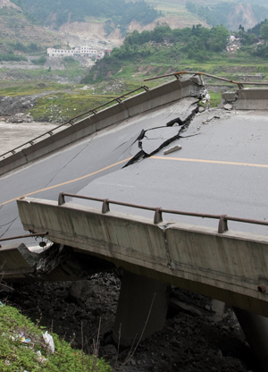
In the aftermath of a major earthquake, local infrastructure is often degraded or destroyed, including systems used by emergency managers to rapidly assess damage and the roads that enable access to sometimes remote disaster areas. Satellites help planners work around the loss of local infrastructure and can provide rapid damage assessments based on before/after imagery, comparing archives to new post-incident acquisitions.
These images – often high resolution – can provide detailed assessment of structural loss, damage to houses, and damage to critical transport infrastructure like roads, rail, and airports. In addition, satellites can effectively monitor for landslides, including in remote areas. Post-earthquake landslides can often block waterways, causing the formation of barrier lakes that themselves present a flood hazard after the initial earthquake hazard has subsided.
Unlike hazards such as tropical storms, it is not yet possible to predict earthquakes, so the ready capacity and global coverage of satellites makes them a uniquely powerful tool for earthquake response managers.