Remote sensing provides a powerful tool for disaster mitigation and preparedness by supporting the mapping of hazards and making systematic observations as an input to risk modeling. Satellite archives contain valuable historical information and new acquisitions can help authorities narrow their focus to the areas of highest risk and optimise preparations and the pre-positioning of response assets. The relative cost effectiveness of using satellite imagery means that much broader areas and a wider range of hazards can be addressed.
For example, the assessment of wildfire fuel loads enables effective hazard reduction burns to be conducted in high-risk areas. These areas are often vast, but satellite imagery can provide cost effective methods for mapping and characterizing fire fuels quickly and accurately, supporting the best-possible mitigation outcomes.
Landslide hazard mapping requires the detailed analysis of past occurrences in relation to their geo-environmental causes. Maintenance of these hazard maps requires continual effort, frequent updates, and the collection of observations over many sites. The consistent and repetitive nature of satellite acquisitions, used in combination with high-resolution airborne images, helps to streamline and scale-up the process.
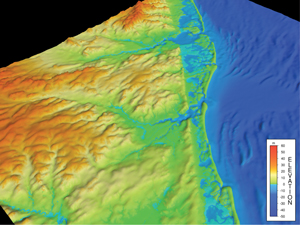
Accurate information on topography is a key input to modeling risks associated with inundation from floods and tsunamis. These models highlight the most vulnerable areas, informing those responsible for civil works like bridges and breakwaters, and enabling planning. Satellites have produced several global, high-resolution digital elevation models which are an essential input to inundation modeling.
Digital Elevation Model, Atlantic City, USA
Image Credit: NOAA
Assessing Drought Vulnerability: Precipitation and Ground Water
The causes of drought are complex and can include extreme heat, reduced precipitation levels, low soil moisture, and the diminished flows of surface and ground water. To date, drought strategy has focused mainly on response management once a drought has set in, but some authorities have begun to place more emphasis on mitigation. Many of the factors governing the occurrence of drought can be measured using satellites and this supports the assessment of vulnerability that enables mitigation and preparation.
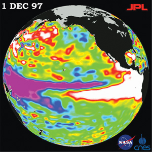
Seasonal precipitation levels across the tropics and subtropics are governed in part by the El Niño Southern Oscillation, which arises due to the effects of anomalous sea surface temperatures off the western coast of South America. Large- scale and frequent monitoring of El Niño is conducted by satellites measuring both temperature, as well as sea level that reflects changing density as seawater heats and cools.
These measurements provide an assessment of precipitation for the coming season, one of the key indicators of impending drought.
In addition to precipitation, ground water plays a major role in determining vulnerably to drought. As drought conditions worsen, the large stores of water in underground aquifers become depleted and this loss of restorative capacity can accelerate the drought impact on the water table and soils above. The amount of water stored in these aquifers is measured globally by satellites detecting small changes in the Earth’s gravitational field from orbit. As aquifer levels fall, authorities can take steps to mitigate impact through water allocations, agricultural markets can adjust in an orderly fashion, and farmers can alter their cropping plans accordingly.
The 1997 El Niño observed by TOPEX/Poseidon
Image credit: NASA/JPL
Producing with Confidence: Crop Insurance
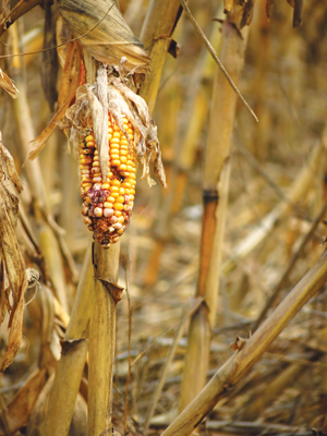
Farming is a risky business, with farmers making considerable up-front investments in crop inputs, such as seed, fertilizer, fuel, and labour, to work the crop and bring it to harvest. A farmer must deal with the precarious nature of the weather, the volatility of commodity prices, and the perils of insects and disease. Crop insurance helps farmers mitigate these risks and sow crops with confidence – however these programmes need to verify claims in order to be sustainable. Farms are often spread across the countryside and in many cases cover vast areas, making on-site inspection costly or infeasible.
Both medium- and high-resolution satellite imagery is employed by government agencies and companies offering crop insurance to verify whether a claim is warranted. Satellite data can provide evidence, helping determine if a crop was planted at all, and if it was, identifying where in the growing cycle issues may have arisen. There are also instances where satellite images support a producer’s claim, for example where the forces of disease, drought, and weather make the claim appear out of the norm.
Satellites make a significant contribution to the mitigation of farmer’s risk relating to extreme weather, drought, and other disasters by helping provide the evidence required to make crop insurance programs viable.