Satellite Earth Observation for Disaster Risk Management
Disasters: A Growing Concern
Natural disasters are of increasing frequency and severity in the modern world. Over the past decade, some 4130 disasters resulting from natural hazards were recorded, causing over 1100000 deaths and a minimum of US$1195 billion in recorded losses. In 2011 alone, 302 disasters claimed around 30000 lives, affecting 206 million people and generating an estimated US$366 billion in damages.1 Rapid growth in the global population and continued urbanisation have brought a dramatic rise in population densities and placed pressure on the development of areas previously undeveloped because of their exposure to risk. Over the past 30 years, the portion of the world’s population living in flood-prone river basins has increased by 114%, and that of those living along coastlines threatened by cyclones has increased 192%. Today, over half of the world’s cities of 2-15 million people are in areas of seismic risk. In parallel, anticipated climate change will likely bring further environmental impacts that will compound existing threats to coastal and flood-plain settlements, as well as increase wildfire hazards and bring stronger and more frequent hurricanes and cyclones. The world’s population has never been exposed to such a high level of risk, and this is likely to grow in the coming years as the same trends continue.
The IPCC Special Report on Managing the Risks of Extreme Events and Disasters to Advance Climate Change Adaptation addresses how integrating expertise in climate science, disaster risk management and adaptation can inform discussions on how to reduce and manage the risks of extreme events and disasters in a changing climate. It evaluates the role of climate change in altering characteristics of extreme events. According to the report, increases in some extreme weather and climate events have been observed in some parts of the world. Further increases are projected over the next decades. For instance, the frequency of heavy precipitation will likely increase in the 21st century over many regions; in other regions, extreme drought has brought renewed risk of wildfires; it is also likely that the average maximum wind speed of tropical cyclones (also known as typhoons or hurricanes) will increase throughout the coming century, although possibly not in every ocean basin. As far as losses are concerned, the report indicates that economic losses from weather- and climate-related disasters have increased, but with large spatial and inter-annual variability. The increased losses are due to increased exposure to risk.
Whether it is the Japanese tsunami in March 2011, the devastating 2010 Haiti earthquake, the Indonesian tsunami of 2004 or the South Asian earthquake hitting Pakistan and India in 2005, catastrophic events leave a mark on our collective memory. Yet these events overshadow other major disasters that arise almost every week. Flooding alone causes dramatic effects annually in China, Bangladesh, Mozambique and other nations. Natural disasters are caused by the impact of natural phenomena on society and the built environment. Re-insurer MunichRe classifies hazards as:
− Geohazards (earthquakes, volcanoes and landslides);
− Hydrometeorological events (windstorms, flooding and avalanches);
− Climatological events (extreme temperature, drought and wildfires); and
− Human-made disasters (from direct human intervention: industrial accidents, chemical spills and nuclear accidents).
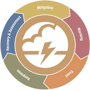
Phases of Disaster Risk Management.
Disaster risk management (DRM) aims to reduce the loss of life and damage to property from disasters. This involves both disaster risk reduction (DRR) such as mitigation/preparedness, prevention/warning activities and other phases such as emergency response, recovery, rehabilitation and reconstruction. Satellite data, particularly Earth observation data, can provide valuable, unique information supporting both research into natural hazards and their causes and operational decision-making tied to both planning and response.
One of the key challenges to address in DRM is the ability to make meaningful contributions to each phase of the disaster management cycle. Limiting contributions to one aspect will necessarily weaken the impact as the phases are interlinked. Indeed, one of the most significant hurdles to further technological contributions to DRM lies in the weak institutional relationships between solution providers and the disaster-management community. These links are best forged between events, in the context of disaster mitigation activities. CEOS and its member space agencies are seeking to develop stronger ties with international and regional coordinating agencies such as UN International Strategy for Disaster Reduction (UNISDR) or the World Bank and the Global Facility for Disaster Reduction and Recovery, in order to promote better use of Earth observation.
Fire Monitoring Examples Using Satellites
Fire risk monitoring providing daily fire risk indexes combining meteorological and EO-based vegetation
information at low or medium resolution to provide global estimates or to support fire prevention and
firefighting services with more accurate risk information.
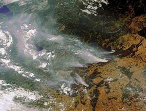
Envisat MERIS image of 29 July 2010 illustrating burning peat fields near Moscow. The city is in the bottom left corner of the image. The smoke plumes stretch over several hundred kilometres and, combined with other air pollutants, can raise pollution levels by a factor of
ten (ESA 2010).
Fire monitoring to detect and monitor fires using medium-resolution satellite
data to provide a ‘global view’ of ongoing
large fires in support to fires
management at regional level, and
transregional/transnational
cooperation of firefighting services.
Rapid mapping with on-request
mapping of burnt areas, at high
resolution just after the event.
Burn scar mapping providing seasonal
mapping of burnt areas and damage
assessment, for better damage
assessment, risk assessment, planning
and land use management.
Identifying the Information Need and Associated Benefits
There are many different actors involved in the DRM process at local, national, regional and international levels. Their capacity to integrate technology and information changes on a geographic and development basis, and their different mandates determine the nature of their varying needs for data and information.
The Group on Earth Observations Secretariat has worked closely with CEOS to understand better the needs of the global disaster management community for satellite-based data. These needs span multiple disaster types, the various phases of the disaster cycle and many satellite data, including:
− medium- and high-resolution optical data;
− medium- and high-resolution microwave radar data (C-, L- and X-band);
− interferometric synthetic aperture radar (SAR) data products;
− infrared and thermal data;
− meteorological datasets and models.
No single organisation or government has a responsibility to meet international requirements for satellite-based DRM data. CEOS can serve a meaningful role in federating diverse requirements and defining key contributions for member agencies to make on a best-effort basis. Working with user organizations to identify resources to leverage initial ‘in-kind’ contributions of data, the international community can make meaningful progress towards increasing the use of Earth observation in DRM. This may enable the purchase of commercial imagery and ultimately increase the number of satellites designed and built to support disaster management.
It is clear from the texts of agreements such as the UNFCCC or other related conventions on biodiversity and desertification that satellite data can help to develop a wealth of information to address monitoring and verification needs. United Nations agencies are currently planning for the post-2015 framework to succeed the Hyogo Framework for Action, with renewed emphasis on concrete action to implement recommendations. In this new framework, satellites may play a critical role, particularly in reducing the underlying risk factors and strengthening disaster preparedness for effective response. Satellite data can supply regular, detailed updates on the status of hazards on a global, regional or national basis.
Reducing the severity of disasters requires the integration of observations, exploiting predictive modelling and disseminating timely and accurate information needed by all actors involved in response and risk mitigation.
Earth observation’s contribution to the provision of refined risk assessment includes up to date localisation and characterisation of the asset at risk; information to support prevention plan elaboration; supporting anticipation (for instance, forecasting and early warning/alert) as well as crisis management operations (rescue, recovery) and to help understand the resulting environmental damages and natural recovery mechanisms better.
It is true that many of the current generation of satellite systems were not designed specifically for DRM activities, with notable exceptions such as the Disaster Monitoring Constellation. However, the rapid pace of technology advance has led to the launch of increasingly flexible and powerful systems. These missions are now multi-purpose and offer exceptional coverage and scope. Taken collectively, the world’s satellite systems offer a unique tool for DRM. CEOS has identified a number of key data requirements for disaster information that can be met by existing systems. For example, the requirements of disaster management centres concerning plain flood hazard have been gathered in consultation with national civil protection authorities: reference mapping are needed within the day of the hazard impact, while rapid mapping of the flood extent is needed within a few hours or within a day, every day. Similar analysis has produced a characterisation of requirements for other hazard types and other phases of DRM such as early warning – for a range of different hydro-meteorological or geophysical hazards – situational awareness during and after disasters, precise damage assessment and support to recovery and reconstruction.
Satellite EO-based Earthquake
Damage Assessment
GIS layer produced by the European Centre
for Training and Research in Earthquake
Engineering (EUCENTRE) for the Italian Civil
Protection Department. The coloured
polygons represent an estimate of the seismic
damage level in three categories of damage
intensity (up to 10% damage, greater than
10%, greater than 30%). The estimate is based
on damage-related statistics from spatial
features in a post-event very high resolution
Cosmo-SkyMed image of the area.
Credits: EUCENTRE, ASI
In the specific area of disaster response, the International Charter ‘Space and Major Disasters’ has established a system to respond to global disasters on a best-effort basis, providing satellite-based information at no cost to disaster-management agencies and the UN. Initiated by ESA, the French space agency CNES and the Canadian space agency CSA, the Charter began operations in 2000 and today has 14 members worldwide. Further to the International Charter, mechanisms such as Sentinel-Asia and SERVIR address similar concerns on a regional basis. In Europe, the European Commission has established Emergency Management Services to address the integration of satellite data for emergencies and is currently collaborating with the International Charter to provide value-adding services to support the exploitation of imagery supplied via the Charter to European organisations for response in areas pertinent to the policy sectors of Europe, primarily in its territories and in regions where humanitarian assistance is invoked.
The use of satellite data for response is now well-established for both natural or man-made disasters. Indeed, it is hard to imagine how response to such man-made catastrophes as the Deepwater Horizon oil spill in the Gulf of Mexico would be possible without the synoptic overview offered by satellite Earth observation. Satellite imagery can be used to track the extent and direction of oil flows for containment and, over time, to identify coastal wetlands adversely affected by the accident.
In the immediate aftermath of a disaster, the primary issue is timeliness. Satellites can provide rapid situational awareness over a large area, typically on a daily basis. This objective, synoptic view of the theatre of operations offers the DRM community a powerful tool to support recovery over the days and weeks that follow a major catastrophe. After the Asian Tsunami of 26 December 2004, the Indian, French and German authorities and the United Nations invoked the Charter and thousands of images from SPOT, Envisat, ERS, IRS, Radarsat, Landsat and US commercial satellites were acquired. Partners produced more than 300 Earth observation-based maps on scales ranging from 1:400 000 to 1:10 000 over Sri Lanka, the Indian coast, the Andaman islands, Africa, the Maldives, Myanmar, Thailand and Indonesia. These mapping actions supported not only relief, but a host of recovery activities. Typically, needs can be as diverse as getting people back to work, getting children back to school, supporting community-driven reconstruction, rebuilding houses, roads, bridges, ports and airports, and reconnecting people: electricity and telephones, reviving the economy, rebuilding irrigation systems, bringing clean water and sanitation, rebuilding health services, restoring damaged ecosystems and protecting the environment, restoring local and provincial governments, managing reconstruction transparently, and developing a disaster-mitigation strategy.
Examples of support provided by the satellite community include the city map of Banda Aceh produced by the GSE Respond project led by Infoterra UK using satellite imagery, hard copies of which were distributed in the streets; and Earth observation-based debris monitoring maps elaborated by the German space agency (DLR ZKI) to help national authorities and aid actors identify and locate debris for removal.
The farther along the continuum from relief to rehabilitation and development, the more satellite Earth observation has a role to play: "emergency assistance must be provided in ways that will be supportive of recovery and long-term development", as laid down in UN Resolution 46/182. This implies that development actors should be involved in the early stages of aid, and that satellite imagery acquired at this time can, and should be, used to support reconstruction and sustainable development.
The impact of response activities such as those of the Charter would be increased by stronger ties to end users through increased DRR collaboration, i.e. in non-emergency activities. This is not without raising financial and sustainability issues. Information needs are different from those of the response phase and require, in particular, large volumes of data over large areas, causing an operational challenge for satellite agencies within the context of existing systems.
There are three major components to the risk reduction activities:
− Vulnerability / Risk Assessment. Here, the central issue is the vulnerability of people and asset to a set of hazards. Once this factor has been weighted properly, one can determine the level of risk that is acceptable to that community or social system.
− Mitigation and Prevention Measures. These are structural or legal/political measures put in place to limit the impact of hazards (mitigation) or avoid this impact altogether (prevention). For example, retrofitting houses on the coastline to withstand tsunami waves or storm is mitigation; enforcing a law that forbids building in the areas of the coast subject to tsunami and storm is prevention.
− Preparedness. These are measures directed to two separate audiences: the population, in order to make people prepared to react to warnings and emergency situations (through drills, exercises, stockpiling, shelters, etc); and the civil protection forces and health sector, in order to increase their ability to respond to disasters (drills, adapted materials, risk maps, hospital drills, evacuation procedures, impact scenarios, GIS, etc).
DRR depends on concrete measures put in place at the community level by informed national and local authorities (ministries of interior, environment, development planning, land use, agriculture, river basing administrations, mayors, civil protection, etc). DRM work relates to different aspects of development and territorial management that concern a variety of domains such as water, sanitation, habitat, transportation and energy. They are managed by different types of organisations with mandates generally attached to a specific domain, for instance basin authorities looking at hydrological risks, geological surveys looking at geohazards such as landslides. Beyond local and national actors, international development organisations such as UNDP and international financial institutions such as the World Bank are involved in development programmes with risk management components.
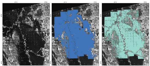
Crisis Mapping and Flooding – Validation Exercise
This exercise was led by a group of experts supervised by the Institute of Geomatics (ES) and the Royal
Military Academy of Brussels (BE). It consisted of a full-scale service delivery based on historical events
and performed under operational constraints including 24/7 availability and the rapid mapping capacity
for rush production of crisis information. As an example, the large plain flooding of the Red River (USA,
April 1997) was selected to validate the flood monitoring service. A total of 14 flood extent products
were rapidly produced compared to a reference flood map derived using 2m resolution air-photos
from a survey performed by the US Army Corps of Engineers. The overall accuracy obtained by the six
value-adding organisations ranges from 81% to 87%. All products were delivered within 28 hours after
the delivery of Earth observation data and 66% of them within 10 hours.
Flood validation exercise: Radarsat-1 image of the flood event, acquired 24 April 1997 (left). Validation ground truth for the same
date, estimated by the US Army Corps of Engineers, St. Paul District (middle). Flood extent estimated for the same date by one of the
Service Providers involved in the exercise (right). Radarsat SAR imagery, 1997: copyright CSA.
Integrated Satellite Earth Observations: A Vision for the Future
Despite the clear successes of initiatives such as the International Charter, which has brought satellite-based Earth observation into mainstream disaster response management, much remains to be done. With regard to conventional methods for improving disaster risk reduction in particular, better use could be made of existing and planned satellite resources. Organisations such as CEOS encourage the use of satellite-based data in the assessment of risk and vulnerabilities. Research initiatives such as the European Commission’s 7th Framework Programme have specifically encouraged the development of new Earth observation-based solutions that will allow disaster managers to use satellite data within the context of either science investigations to characterise hazards and risks better or operational systems to support disaster management authorities. On a global basis, organisations such as GEO encourage the development of an international approach to forge greater ties between those that generate satellite-based information and those that need to use it. This institutional bridge-building includes both capacity-development activities and the elaboration of a systematic approach for using global datasets in risk-prone areas. Achieving long-term results requires commitment both from data providers (in terms of data continuity, new sensors and evolving requirements) and from the users, who are often unfamiliar with the opportunities afforded by new technologies.
As DRR activities are increasingly undertaken with national and regional users, through the sponsorship and guidance of international players – be they international financial institutions such as the World Bank or development agencies such as the UN Development Programme – the uptake of new systems and satellite-based data in operational support to disaster management will increase. There is nothing planning can do to reduce the number and severity of hazards. Ultimately however, while less prominent in the eye of the media, the integration of relevant, timely and comprehensive datasets into disaster mitigation activities will be the largest factor contributing to reducing the loss of life and damage to property. Improved understanding of risk and risk extent, improved planning, better preparedness and systematic efforts towards risk reduction based on long-term development and environmental concerns will achieve the ultimate goal of reducing the number and scale of actual disasters caused by hazards.
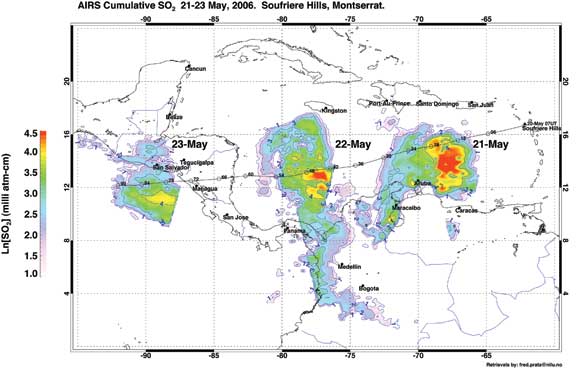
Volcanic Hazard Monitoring
Satellite Earth observation data are used for different facets of DRM concerning volcanoes and volcanic ash. Historical analysis using Earth observation data can help to identify and characterise eruption types and their probability of occurrence. Earth observation-based monitoring is used to support the characterisation of the state of a volcano. This includes terrain elevation measurements and terrain deformation monitoring using spaceborne SAR data. InSAR is now a recognised technique in the early detection of magma injection and in monitoring the stability of the underlying structure of a volcano. In addition, infrared and multispectral sensors are useful for observations of the thermal output of an eruption and estimates of the height and behaviour of the eruption column and observations of the movement and extent of the ash cloud, in particular, thermal anomalies and estimates of gas and aerosol composition. (source: Monitoring Volcanic Ash from Space, ESA Publication STM-280).
Soufrière Hills volcano, Montserrat, following the eruption of 20 May 2006. The image shows SO2 retrievals on seven consecutive days, from
the Atmospheric Infrared Sounder (AIRS on EOS-Aqua), to measure atmospheric profiles of temperature, moisture and trace gases
for climate and weather prediction applications. Trajectories from an atmospheric dispersion model overlaid on the plot confirmed a high,
stratospheric SO2 cloud. Cloud behaviour was monitored every 15 minutes using MSG-SEVIRI data. Credit Fred Prata (fred.prata@nilu.no)