ceos   eesa
CEOS EO HANDBOOK –
EARTH OBSERVATION SATELLITE CAPABILITIES AND PLANS
Capabilities of Earth Observation Satellites
   
Atmospheric Chemistry Instruments
Atmospheric Temperature and Humidity Sounders
Cloud Profile and Rain Radars
Earth Radiation Budget Radiometers
High Resolution Optical Imagers
Imaging Multi-Spectral Radiometers (vis/IR)
Imaging Multi-Spectral Radiometers (Passive Microwave)
Imaging Microwave Radars
Lidars
Multiple Direction/ Polarisation Instruments
Ocean Colour Instruments
Radar Altimeters
Scatterometers
Gravity, Magnetic Field and Geodynamic instruments
  Earth Observation Plans by Measurement  
Catalogue of Satellite Missions
Catalogue of Satellite Instruments


SCATTEROMETERS
Description
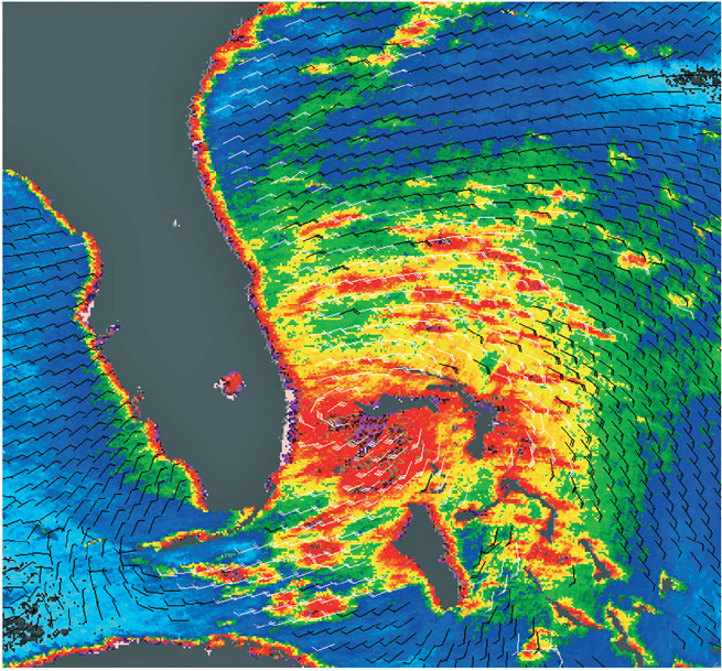
A scatterometer transmits radar pulses and receives backscattered energy, the intensity of which depends on the roughness and dielectric properties of a particular target. Scatterometers were originally designed to measure oceanic surface winds, where the amount of backscatter depends on two factors – the size of the surface ripples on the ocean, and their orientation with respect to the propagation direction of the pulse of radiation transmitted by the scatterometer. The first is dependent on wind stress, and hence wind speed at the surface, while the second is related to wind direction. As a result, measurements by scatterometers may be used to derive both wind speed and direction.

The main aim of these instruments is to achieve high accuracy measurements of wind vectors (speed and direction), so resolution is of secondary importance. (They generally produce wind maps with a resolution of order 25–50 km). Because scatterometers operate at microwave wavelengths, the measurements are available irrespective of weather conditions.

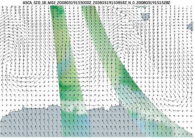
Spaceborne scatterometers have provided continuous synoptic microwave coverage of the Earth for nearly two decades, starting with the ERS series in 1991, NSCAT on ADEOS, SeaWinds on QuikSCAT, and more recently ASCAT on MetOp. The ERS and NSCAT instruments employed a fan-beam (multi-incidence) wind retrieval technique, whereas QuikSCAT employs a conically scanning (fixed incidence) technique. Increases in swath width capability now mean that a single instrument can provide around 90% coverage of global oceans on a daily basis.

Applications
Information from scatterometers provides a unique source of data on sea surface wind speed and direction. This has important applications in weather and wave forecasting, the investigation of climate models and elaboration of marine wind climate. The assimilation of scatterometer data into atmospheric forecasting models greatly improves the description of cyclonic features which are so important in predicting future weather patterns.

A large number of new, unforeseen, terrestrial and sea ice applications has emerged beyond the original ocean winds mission of scatterometers. These include: the measurement of sea ice extent and concentration; soil moisture; snow accumulation; and regional monitoring of ice shelves, rainforests and deserts. The daily global coverage of scatterometers in the polar regions and their ability to discriminate sea ice, ice sheets and icebergs, despite poor solar illumination and frequent cloud cover, make them excellent instruments for large-scale systematic observations of polar ice.

Current and planned Instruments
Advanced Scatterometer Scatterometer
Aquarius L-Band Scatterometer Scatterometer
ASCAT SeaWinds
SCAT WindRAD
Tropical storm Katrina observed on 25 August 2005 off the Florida coast before it had reached hurricane status.
ASCAT wind measurements south of Australia on 19 March 2008. Superimposed is an ECMWF
forecast 10 m wind field.
Darker colours correspond to areas of low surface wind speeds. Colour tone changes correspond to changes in the surface wind direction, as the sensitivity of the measurement from the different antenna beams varies with the relative direction of the surface wind vector with respect to the viewing direction of each beam.
Further Information
ASCAT: www.esa.int/esaLP/SEMBWEG23IE_LPMetop_0.html
Aquarius: aquarius.gsfc.nasa.gov
SeaWinds: winds.jpl.nasa.gov/missions/quikscat/index.cfm


©Copyright 2011 CEOS Print CopiesResearched and written by SymbiosDesigned and built by Beaucroft