ceos   eesa
CEOS EO HANDBOOK –
EARTH OBSERVATION SATELLITE CAPABILITIES AND PLANS
Capabilities of Earth Observation Satellites
   
Atmospheric Chemistry Instruments
Atmospheric Temperature and Humidity Sounders
Cloud Profile and Rain Radars
Earth Radiation Budget Radiometers
High Resolution Optical Imagers
Imaging Multi-Spectral Radiometers (vis/IR)
Imaging Multi-Spectral Radiometers (Passive Microwave)
Imaging Microwave Radars
Lidars
Multiple Direction/ Polarisation Instruments
Ocean Colour Instruments
Radar Altimeters
Scatterometers
Gravity, Magnetic Field and Geodynamic instruments
  Earth Observation Plans by Measurement  
Catalogue of Satellite Missions
Catalogue of Satellite Instruments


HIGH RESOLUTION OPTICAL IMAGERS
Description
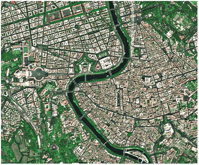
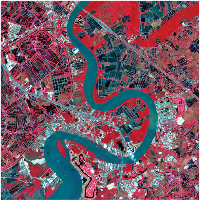
High resolution optical imagers provide detailed images of the Earth’s surface. In general, these are nadir-viewing instruments with a horizontal spatial resolution in the range 10 to 100 m and swath widths of order 100 km. In the past few years, high resolution sensors have emerged with spatial resolution in the range 1 to 5 m. An increasing number of government-funded and private sector-funded sensors with sub 5 m resolution are planned for the coming years.

High resolution imagers are, in general, panchromatic (a single waveband) and multi-spectral (multiple waveband) sensors, with spectral bands in the visible and IR range which are simultaneously recorded. This increases the information content that may be derived from the imagery (including the ability for land cover classification) and allows corrections to be made, for example, for the effects of atmospheric water vapour on the measured surface parameters. In order to reduce atmospheric absorption and to increase image quality, the operating wavelengths of these instruments are selected to coincide with atmospheric windows.

Use of these sensors can be limited by weather conditions, since they are unable to penetrate thick cloud, rain or fog and are typically restricted to fair weather, daytime-only operation. Some have pointing capability which enables imagery of specified areas to be acquired more frequently. Many countries, including developing countries, have and/or are planning high resolution optical imaging missions. Future trends will include a greater number of sampling channels, as well as improved spectral and spatial resolution. More instruments will also become available that are capable of producing stereo images from data collected on a single orbit, i.e. along track, as opposed to across track, so that stereo images can be acquired from different passes.

Applications
High resolution optical imagers are amongst the most common Earth observation satellite instruments, finding application in, for example:

— agriculture, including definition of crop type and area, crop inventory, yield prediction and crop stress identification;

— damage assessment associated with natural hazards;

— geological mapping;

— urban planning, including land cover mapping, topographic mapping and urban development monitoring;

— cartography, including map generation and updating, generation of digital elevation models;

— environmental planning and monitoring.

Current and planned Instruments
AEISS MSS
AEISS-A MSS
ALI MSU-200
ASTER NigeriaSat Medium and High Resolution
ATCOR PAN
BGIS 2000 PAN
Event Imaging Spectrometer from GEO (GeoCape) PAN
Geoton-L1 PAN (Cartosat-1)
High Resolution Panchromatic Camera PAN (Cartosat-2)
HiRI PAN (Cartosat-2A/2B)
HRG PAN (Cartosat-3/3A)
HRS PAN (GISTDA)
HRTC PAN CAM
HRVIR PAN CAMERA
HSI PAN+MS (RGB+NIR)
LISS-III (RESOURCESAT) PSS
LISS-IV SLIM-6
MSC SLIM-6-22
MSI TES PAN
MSI (Sentinel-2)  
SPOT 5, launched in May 2002, features imaging sensors with 2.5 m resolution.
This image is of Rome.
A town in Thailand imaged by the LISS-IV sensor on ISRO’s Resourcesat-1.
Further Information
ALOS (AVNIR-2 & PRISM): www.jaxa.jp/missions/projects/sat/eos/alos/index_e.html
SPOT: www.spotimage.fr
Landsat: landsat.usgs.gov
CBERS: www.cbers.inpe.br/en/index_en.htm
TOPSAT: www.qinetiq.com/home/defence/defence_solutions/space/topsat.html


©Copyright 2011 CEOS Print CopiesResearched and written by SymbiosDesigned and built by Beaucroft