|
|
|
| LAND SURFACE CHANGE |
|
The extent and rate of land use change are directly related to human population growth. The impact of such change on the landscape has far reaching effects on our environment, including climate. The conversion of forest to agriculture, for example, contributes significantly to changes in atmospheric CO2 concentrations and in other greenhouse gases. It can also modify land surface/atmosphere interactions (e.g. surface roughness, albedo and humidity) that affect other important environmental processes, including temperature and precipitation patterns.
A large number of regional, national and global research efforts are dependent on improved understanding of the land surface which, in turn, supports decision makers who are concerned with societal vulnerability and the environment. This information often stands alone as evidence of environmental change or is used to help parameterise ecological and climate models.
|
|
|
Furthermore, land use intensity has steadily increased with the Earth’s population growth since the Industrial Revolution. Advances in technology, especially in the agriculture and forestry sectors, have accelerated the changing face of the land surface. Human action has transformed almost half of the Earth’s land surface, with a 50% reduction in the area of tropical forests that will have significant consequences for global biodiversity and climate.
The degradation of environmental quality has far-reaching effects, including a reduction in coastal fisheries production, poorer water quality, and reduced biodiversity. Regular updates of global land cover and land cover condition are required to improve our understanding of nearly every aspect of the changing environment, including fluxes of water, carbon dioxide and other trace gases; changing coastlines and their influence on marine resources; biodiversity; and biosphere/atmosphere interactions. |
|
|
 |
|
|
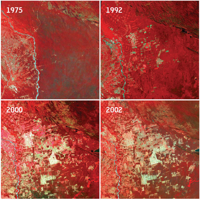
Landsat time series of large scale deforestation in the Amazon. |
|
|
|
|
Sustainable Forestry
Sustainable forestry is one of the most challenging land use practices that humans are facing. The changing shape and condition of the Earth’s forests affect biodiversity, atmospheric composition and climate. Satellite observations provide a consistent set of information about forests over large areas that are otherwise difficult to inventory and monitor. Such observations provide forest managers with the information needed to evaluate the potential impact of different uses and manage forests with sustainable practices. Global Observation of Forest and Land Cover Dynamics (GOFC-GOLD) is a coordinated international effort that is working to provide ongoing space-based and in situ observations of forests and other vegetation cover. It is intended to support the sustainable management of terrestrial resources and to obtain an accurate, reliable, quantitative understanding of the terrestrial carbon budget. Originally developed as a pilot project by CEOS, as part of its Integrated Global Observing Strategy, GOFC-GOLD is now a panel of the Global Terrestrial Observing System (GTOS).
Other major forest-related efforts that rely on Earth observation data are under way around the globe. The UN Food and Agriculture Organisation’s Forest Resource Assessment 2010 is a decadal update of the world’s forest resources that is dependent upon satellite-based data. The Brazilian Instituto Nacional de Pesquisas Espaciais (INPE) is utilising Landsat data for annual monitoring of forest resources in Amazonia under their Programme for Deforestation Assessment (PRODES) project in the Brazilian Legal Amazonia. The United Nations Framework Convention on Climate Change (UNFCCC) identified Reduction in Emissions from Deforestation and forest Degradation (REDD) as a key element of the UN Bali Action Plan and it may well lead to increased emphasis on utilising satellite resources for sustainable forestry practices. |
|
|
Agricultural Monitoring
Assessing the need for enhanced agricultural observations (satellite and in situ) is a responsibility of the Integrated Global Observations of Land (IGOL) programme. IGOL advises the Group on Earth Observations (GEO) on the requirements for improved observation of the land surface. GEO recognises sustainable agriculture as one of the critical Societal Benefit Areas (SBAs) for international cooperation and collaboration. The agricultural SBA calls for an operational system for monitoring global agriculture that includes the following three main functional components:
— global mapping and monitoring of changes in distribution of cropland area and associated cropping systems;
— global monitoring of agricultural production leading to accurate and timely reporting of national agricultural statistics, and accurate forecasting of shortfalls in crop production and food supply that facilitate reduction of risk and increased productivity at a range of scales;
— effective early warning of famine, enabling the timely mobilisation of an international response in food aid.
Examples of current global crop estimation systems include those of the United States Department of Agriculture Foreign Agricultural Service (FAS-USDA) and European Commission – Monitoring Agriculture with Remote Sensing (EC-MARS), which combine weather data, in situ information and satellite data to estimate production and yield. Food supply assessments inform risk and damage assessments, as well as farming practice monitoring and drought assessment. |
|
|
 |
|
|
ESA's GLOBECOVER project created the most detailed land cover map ever.
For this mosaic a total of 1561 orbits taking place over the period May, July, October and November 2004 were used to filter out the clouds. |
|
|
|
|
Land Cover
A number of global and regional land cover mapping efforts using Earth observation data from satellites have been undertaken over the past decade by utilizing sensors such as AVHRR, MODIS and SPOT Vegetation. A new, 300 m resolution global land cover map has been released by the POSTEL Service Center that uses the MERIS sensor aboard the Envisat satellite. A number of national and regional land cover data sets, including the National Land Cover Database (NLCD) for the USA, CORINE for Europe, and Africover for eastern Africa, have been developed at 30 m resolution. This level of detail is necessary for detecting and characterising land cover change. For instance, the NLCD products support other land cover research projects around the United States, such as the Fire Danger Monitoring and Forecasting Project.
The Role of Satellite Earth Observations for GCOS Terrestrial Requirements
A number of CEOS agencies’ assets are currently being used to meet the terrestrial requirements that are outlined in the Global Climate Observing System’s Implementation Plan. These include altimetry missions to help estimate lake area, characterisation of snow and ice sheets from optical and microwave sensors, global land cover characterisation and albedo estimates. Other Essential Climate Variables required by GCOS, such a fAPAR, biomass and soil moisture, are current areas of research and development when considered at the threshold levels required by GCOS. |
|
|
CEOS Virtual Constellation for Land Surface Imaging
Data acquired by land remote sensing satellite systems are fundamental tools for studying the Earth System, including the land surface and the processes that operate on or near it. These data are sources of information from which meaningful interpretations can be made about the Earth’s biological conditions and resources, geologic and hydrologic processes and resources, and human dynamics. |
|
|
 |
|
|
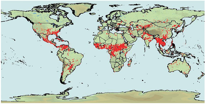
Global web fire mapping service using MODIS |
|
|
|
|
Since the launch of Landsat-1 in 1972, there has emerged a large and diverse international community of users who apply remotely sensed data collected by the same land surface imaging satellites, now operated by many nations, to a wide range of different scientific and practical endeavours. These include environmental monitoring, natural hazard assessment, vegetation analysis, geologic investigations, infectious disease control, natural disaster mitigation, wetlands assessment, cartography, land use and land cover classifications, glaciology, coastal and sea floor mapping, global change studies, forestry, wildlife studies, hydrology, agriculture, and many more. These endeavours have had positive effects on Earth’s natural habitats and environments, the economic state of society and the well-being of mankind. Yet, many more benefits to society remain to be realised from the application of such data.
The design, construction, launch, and operation of satellite systems are complex and very expensive endeavours. Ideally, nations would not develop duplicative satellite systems, but rather would collaborate fully in the development, launch, operation and sharing of data from a constellation of satellite systems that optimally meets their full range of land surface observational requirements. That day likely will come, but it is not here yet.
Until then, CEOS has initiated the Virtual Constellations Concept by establishing four original prototype virtual constellations, including the Land Surface Imaging (LSI) Constellation. A primary objective of the LSI Constellation is to define a broad range of rather detailed characteristics (or standards) that describe the optimal, end-to-end capabilities (and policies) needed to acquire, receive, process, archive and distribute space-acquired land surface image data to the global user community. |
|
|
Ideally, users will find such data optimally applicable to the broadest possible range of scientific and practical endeavours important in meeting the needs of society. The beneficial outcomes from defining such standards will be the guidance they provide for the internationally coordinated development of future systems, as well as the foundation they provide for establishing criteria against which future proposed Earth observing systems can be assessed.
Another important objective of LSI Constellation studies and activities is to address current and shorter-term problems and issues facing the land remote sensing community today. One way the LSI Constellation is addressing these problems and issues is by promoting greater cooperation among CEOS space agencies that currently operate land surface imaging satellite systems. The important outcomes from accomplishing this objective lie in the early benefits that will be derived by many segments of the land remote sensing user community, and by society in general, as well as the opportunity to demonstrate the value that CEOS Constellations can contribute to the Group on Earth Observations (GEO) and its member organisations. |
|
|
 |
|
|
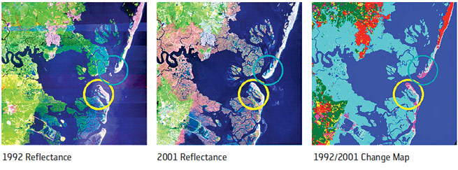
Erosion and accretion along barrier islands near Beach Heaven, New Jersey, USA.
This area on the New Jersey shoreline contains small but notable changes in the barrier island complex due to wave action.
Although only 1.67% of all pixels in this area were identified as changed, there are economic consequences when high value urban real estate
from Beach Haven, NJ, is transported down the coast. |
|
|
|
|
| Currently, the LSI Constellation is working with CEOS agencies that operate mid-resolution optical LSI satellite systems, contributing data to the Forest Resource Assessment 2010 Project to fill gaps in its base data set. It is also responding to a GOFC-GOLD proposal to compile a global, mid-resolution optical data set centred on 2010 by initially creating regional data sets contributed by CEOS agencies. |
|
|
| Other cooperative activities among CEOS agencies that are being initiated by the LSI Constellation Study Team include those designed to improve user access to existing LSI data sets, to coordinate acquisition of data, and to increase compatibility in ongoing ground segment operations. |
|
|
 |
|
|
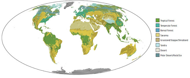
Map of natural vegetation types that likely would exist if there were no human agricultural utilisation.
The expansion of croplands and pastures came at the expense of natural ecosystems, including forests, grasslands and savannas. |
|
|
|
|
 |
|
|
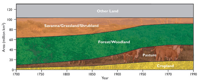
Changes in land cover during the last 300 years due to agricultural expansion.
During the last 300 years there has been a large increase in the amount of land devoted to agriculture (croplands and pastures) coming at
the expense of natural ecosystems. As human population and material consumption continue to increase, the pressure on our finite land
base will also continue to increase.
(Data from the Center for Sustainability and the Global Environment, University of Wisconsin) |
|
|
|
|
|
|