Aerosols
Aerosols are tiny particles suspended in the air. The majority are derived from natural phenomena such as volcanic eruptions, but it is estimated that some 10% are generated by human activities such as burning of fossil fuels. The majority of aerosols form a thin haze in the lower atmosphere and are regularly washed out by precipitation; the remainder are found in the stratosphere where they can remain for many months or years. Scientists have yet to quantify accurately the relative impacts on climate of natural aerosols and those of human origin, and are unsure as yet whether aerosols are warming or cooling the Earth. Predicting the rate and nature of future climate change requires this understanding.
The IPCC identifies further information on aerosols as a priority requirement and highlights a particular need for additional systematic, integrated and sustained observations, including observations of the spatial distribution of greenhouse gases and aerosols. The Integrated Global Atmospheric Chemistry Observations (IGACO) Theme of the IGOS Partnership aims to provide a framework ensuring continuity and spatial comprehensiveness of the full spectrum of atmospheric chemistry observations, including the monitoring of atmospheric composition parameters related to climate change and environmental conditions. The IGACO Theme Report (available from www.igospartners.org) was finalised in May 2004 and provides a comprehensive overview of current and future satellite measurements for tropospheric and stratospheric aerosols The report states, in particular, that “satellite observations of aerosol optical properties have progressed to a point where they range from pre-operational to operational, although there are demonstration-mode instruments on a number of research satellites”.
Reliable information on aerosols is also required by applications outside the study of the climate system.
For example, accurate and timely warnings of the presence of airborne dust and ash - such as that arising from desert dust clouds and volcanic eruptions - is important to the safety of airline operations. A worldwide volcanic ash monitoring system, which is dependent on satellite observations, is in place to provide real time advice to pilots.
Measuring the distribution of aerosols through the depth of the atmosphere is technically difficult, particularly in the troposphere, and previously, techniques using instruments such as AVHRR and ATSR were limited to producing estimates of vertically-integrated total amounts, mainly over oceanic regions.
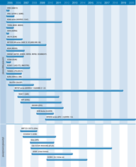
Measurements over land are difficult (due to both persistent cloud cover and to the high value, and variability, of land surface reflectance) but the new generation of multi-directional or polarimetric instruments - such as AATSR, MISR and APS (planned) - can provide detailed information. Today, MODIS, MERIS and MISR offer better optical depth at different frequencies from which aerosol particle sizes, particularly over oceans, may be inferred. The development of active instruments such as ATLID, and laser altimeter sensors, including GLAS on ICESat (in orbit since January 2003), should yield much improved measurement capability. In 2005, CALIPSO will fly a 3-channel lidar (designed specifically to provide vertical profiles) and passive instruments in formation with Aqua, Aura (both already in operation), Parasol and CloudSat to obtain coincident observations of radiative fluxes and atmospheric state. This comprehensive set of measurements is essential for accurate quantification of global aerosol and cloud radiative effects.
Limb-sounding instruments such as ACE-FTS, SCIAMACHY, GOMOS, and HIRDLS provide data principally on the upper troposphere and stratosphere with high vertical resolution, but relatively poor horizontal resolution (typically of the order of a few hundred km).
AVHRR/3 on the NOAA and METOP series will continue current limited capabilities to provide estimates of total column aerosol amounts over the ocean, and SEVIRI on MSG will have similar capabilities, but with increased temporal resolution. AVHRR/3 will be replaced by a more capable visible and infrared imager, called VIIRS, on the NPOESS series of satellites, starting with the preparatory NPP mission in 2006. VIIRS will acquire high resolution atmospheric imagery and generate a variety of applied products including some giving information on atmospheric aerosols.

