Satellites provide indispensible observations of many of the phenomena that contribute to the development of tropical storms, improving both short-term warnings and forecasts and our understanding of long-term trends. Sea surface temperature (SST) is key for the formation of tropical storms; satellite measurements using both optical and microwave instruments provide forecasters with global views of changing conditions. Increased SST can feed storms by drawing more water vapour into the system, and satellites provide unique global soundings of atmospheric temperature and humidity that greatly improve the accuracy and skill of forecast models. Satellite-based radar scatterometers and altimeters provide key measurements of sea surface wind speed and topography, both of which are key markers of building storm intensity, and also help forecast probable direction.
Tracking Tropical Storms
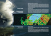
Tropical storm tracking capabilities have been greatly enhanced since the 1970s - notably with the recent launch of the first of the next-generation of geostationary imagers (Japan’s Himawari-8), to be followed by the USA’s GOES-R. Storm tracks can now be routinely monitored every 10 minutes and as frequently as every 2.5 minutes during critical periods. New spectral bands, and greatly improved spatial resolution on next-generation geostationary imagers provides meteorologists with a steady flow of composite 3-D colour images showing individual cloud formations, moisture levels and temperature variations. These new data streams represent a revolution in near real-time forecasting, enabling earlier identification of changes in cloud cover and structure, rain, and wind speeds that indicate the formation of a tropical storm. These observations can be translated into earlier warnings and improved forecast accuracy and range.
Monitoring Precipitation
A new generation of precipitation monitoring satellites are advancing our understanding of the Earth’s water and energy cycle, improving predictions of weather, climate and freshwater resources. Understanding the current variability of precipitation is critical to better modelling future extreme weather events, and satellites provide global observations on sub-daily to decadal time scales.
The Microwave Imager and Dual-frequency Precipitation Radar carried on the GPM satellite enhance our extreme weather monitoring and prediction capabilities, providing unprecedented visibility of precipitation inside complex storm systems. A planned constellation of satellites built around GPM would make possible near real-time estimates of rain and snow every 2–4 hours anywhere on the globe. GPM is also helping to build the long-term record of global precipitation essential to our knowledge and understanding of climate variation. It builds on the legacy of previous precipitation monitoring satellites, extending the time series and advancing measurement capabilities.