Glaciers and Ice Sheets ECVs: Sea ice, Ice sheets (terrestrial), Glaciers and ice caps
Systematic Monitoring of Remote Locations
The Earth’s ice sheets and glaciers cover a vast area and can be remote and difficult to access, which makes their systematic monitoring a significant challenge. While some may be measured by ground instruments, satellites enable regular monitoring on a scale and with a frequency that cannot be replicated in–situ. A number of satellite observations are employed to measure changes in the extent, thickness and density of ice sheets, allowing for improved and reconciled estimates and the assessment of long-term trends.
Altimetry data from radar and laser instruments provide mass balance estimates by measuring surface topography and volume change. Synthetic aperture radar (SAR) imagers also enable the detailed study of changes in the surface through interferometry, which uses the unique range information from successive, closely timed radar observations to detect small changes in topography. SAR also provides valuable all-weather observations in frequently cloudy areas to regularly assess changes in ice sheet boundaries. Measurement of fluctuations in the Earth’s gravitational field by the GRACE mission allow regional average changes in ice sheet mass to be measured directly.
These unique measurements have been applied to major ice sheets and glaciers in Greenland and Antarctica, as well as in other locations globally, enabling detailed analysis of change with a frequency of monthly or better. In addition to new measurements, some archives date back more than 20 years, enabling historical comparison.
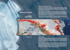
Antarctic Ice Sheets
Satellite radar imagery of Antarctica’s Larsen C ice shelf – which is two and a half times the size of Wales – has shown that it lost four metres from its thickness between 1998 and 2012. As they thin, ice shelves become prone to collapse, with nearby Larsen A and Larsen B collapsing in 1995 and 2002 respectively. While vast, the amount of water contained in these shelves is insignificant in terms of its impact on sea level rise, but the glaciers they help contain are of some concern to scientists and may pose a risk to coastal communities around the world. The glaciers behind Larsen C hold enough water to add a few centimetres to global sea level.
In the nearby Bellingshausen Sea, satellites have observed a sudden dramatic change in the behaviour of glaciers on the Antarctica Peninsula. A Bristol University-led study looked at more than 10 years of satellite observations, noting that these ice streams were broadly stable until 2009, but since then they have been losing on the order of 56 billion tonnes of ice per year to the ocean. Scientists used radar altimetry measurements from the Cryosat mission, with gravity measurements from GRACE used to check the results. While these measurements, and the cause of the changes, need to be interpreted in the broader context of the overall Antarctic climate, signals like these are essential for building knowledge and understanding and for monitoring risk. The role of satellites in the timely detection of these signals is unique.