The Building Blocks of Climate Monitoring from Space
In order to make decisions on climate change mitigation and adaptation, the UNFCCC requires a systematic monitoring of the global climate system. Satellite data play a crucial role in climate monitoring, research and services.
The journey taken by these data, starting from satellite instruments above to the climate scientists and decision makers on the ground, is a long and varied one. Each step on the journey may be considered as a building block. Each building block works with others on the same journey, building data step by step into a final usable form, a form valuable to policy makers and scientists alike. Together, these building blocks form the “climate monitoring architecture”.
Building Block #1: Gathering Raw Data from Space
Sophisticated instruments flying in space gather valuable geophysical information about the Earth. In contrast to instruments on the ground, the instruments above have the advantage of gathering data on a global scale. Climate change is a global phenomenon, requiring global data.
For over 30 years, a broad variety of satellites have gathered, and continue to gather, valuable raw data about the Earth.
However, the Earth’s climate changes slowly relative to the lifetime of any individual satellite. Therefore, to build a “Climate Data Record”, scientists need to stitch together many different sources of raw data spanning many years, satellites old and new, from numerous space agencies. This involves digging into archived data, incorporating new satellite data as it reaches the ground and planning well for the next generation of satellite missions.
Archived Data
Past weather and climate observations have left an enormous legacy of archived data that forms the basis of our current knowledge on climate variability and change. Additionally, although optimised to support real- time weather monitoring and forecasting, operational meteorological programmes of the past have also provided a foundation for long-term climate records of key climate parameters.
Current Data
Approximately 100 satellites are currently operating with an EO mission. Increased frequency of satellite measurements, improved satellite and sensor technology and easier access and interpretation of EO data are all contributing to the increased role of satellite data in our knowledge of the climate system.
As data from currently flying satellites arrive on the ground, they become available to scientists for stitching together, blending and processing with data from other sources.
The new data are then archived for posterity, for use by the next generation of climate projects, programmes, scientists and engineers.
Planning for the Future
Some 140 civil EO satellite missions are planned for launch over the next 15 years. These missions will carry over 400 different instruments to measure components of the climate system, including the atmosphere, ocean and land surface.
The lifetimes of these satellite missions span many years, beginning before their launch. The first step in the life of a satellite mission is consulting with climate science organisations, and many other stakeholders, on their climate science needs.
These needs typically arise from shortfalls in the stitching together, and other processing, for production of Climate Data Records for the international community.
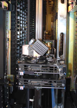
Figure 1: NOAA’s robotic archive with packages of tape cartridges with each tape holding 1.5 terabytes of data. Robotic tape libraries allow preservation and ready access to satellite data collected over the past 30 years.
Building Block #2: Producing and Preserving Climate Data Records
With the gathered raw satellite data in hand, the objective of Building Block #2 is to process this input into Climate Data Records. This building block comprises many mini building blocks to form a “Processing Chain” that shapes this raw input into a final usable form. These mini building blocks include, for example, the computational stitching together of the different sources of raw input data, calculation of numerical uncertainties and the application of state-of-the–art scientific algorithms distilled from the latest scientific reasoning.
Climate Viewpoints
A huge variety of Climate Data Records exist, each formed from a particular viewpoint on climate. Examples include the amount of greenhouse gas in the atmosphere, the height of the oceans or the temperature of the land. Each viewpoint requires a unique blend of raw data and mini building blocks on their processing chain to suitably reflect the viewpoint.
Fifty such viewpoints, termed Essential Climate Variables (ECVs), have been defined by GCOS in support of the UNFCCC, 28 of which have been deemed both technically and economically feasible for systematic observation from space.
To generate Climate Data Records targeted to each ECV, climate scientists strive to gather the right blend of raw data and get the right assortment of mini building blocks to form an appropriate processing chain. In particular, scientists aim to meet the “Target Requirements” defined by GCOS for each ECV.
Reaching for Clearer Views
These GCOS target requirements quantitatively express the desired characteristics of Climate Data Records for each ECV needed by the UNFCCC for the systematic observation of climate.
Climate scientists are striving to bring together their latest scientific thinking, applied to data old and new, to produce Climate Data Records to reach these targets. The science is supported by space agencies and other international bodies working together, enabling the resources required to reach these targets.
Taking a Snapshot
A snapshot of all Climate Data Records, and how each compares against the GCOS target requirements, is compiled by CEOS and CGMS in the form of an ECV Inventory.
The ECV Inventory tabulates the current state of affairs in the production of Climate Data Records taking aim at the GCOS target requirements. CEOS and CGMS use their inventory to further work together to report to the UNFCCC on their progress.
Looking to the future, the ECV Inventory also forms the backbone of material used by CEOS and CGMS in coordinating where to best plan future resources. For example, the exchanging of raw data between two scientists for their processing chains may prove the solution to meeting a currently unmet GCOS requirement, whereas the planning of one new mission for launch in 30 years time may be another.
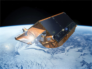
Figure 2: Cryosat-2, now in orbit
Building Block #3: Applying Climate Data Records
Climate Data Records are applicable to hugely diverse and numerous socio-economic areas. Following consultation with stakeholders, sponsors and affiliate scientists over several years, the WCRP published a categorisation of major areas of scientific research, analysis and observation, termed Grand Challenges. The Climate Extremes Challenge, for example, requires decadal data to support adaptation planning, focusing on heavy precipitation, heat wave, drought and storm.
For climate services in societal sectors such as food security, water, energy, and health, the major direct or indirect value of satellite-based climate data records has been demonstrated through case studies developed by the CEOS/CGMS Working Group on Climate. Reference: http://www.wmo.int/pages/prog/sat/documents/ARCH_ ClimateServiceCaseStudies.pdf
Each application of climate data will have its own particular requirements to fulfil the needs of that specific application. Tailoring of climate data products is commonly necessary, in order to hone in to the requirements of the application in question.
This poses significant engineering demands. International coordination is underway in Europe in the form of the Copernicus Climate Change Service and globally via the WMO’s Global Framework for Climate Services.
Building Block #4: Decision Making
Decision makers are engaged by the scientific community in a number of ways. Often there are common regional challenges, for instance shared coastal resources such as a bay or river delta. Alternately, engagement is accomplished by identifying sectors, such as agriculture or energy, that share common needs.
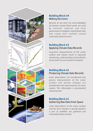
Putting it all Together
Opposite is an end-to-end example of the climate monitoring, research and services building blocks.
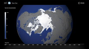
Figure 3: A computer visualisation of sea ice concentration in March 1992, constructed using the ESA Climate Data Record for sea ice
Figure 4: An end-to end-example of the climate monitoring, research and services building blocks applied to Sea Level Rise and Impact on Coastal Regions. Removing any one building block will topple all those above.
Article Contributors
Pascal Lecomte (ESA), Ed Pechorro (ESA), John Bates (NOAA)